


Archaeological Survey: Complete Field Methods Guide
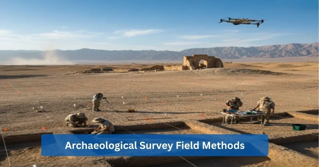
Among the methods of modern archaeological research, archaeological survey is still the most significant. It allows you to identify, record, and interpret past cultures in a non-invasive manner. The systematic investigations of these surveys yield significant data for the protection of cultural heritage and academic research.
This complete guide covers all parts of archaeological field surveys. You’ll learn how archaeologists find out about the past using everything from old-fashioned methods like field walking to new technologies like drones with AI.
What Is an Archaeological Survey?
Archaeology is the scientific study of the human past through material remains, including artifacts, architecture, and cultural landscapes, ranging from early human ancestors to modern, 20th-century sites. It utilizes methods like survey, excavation, and analysis of material culture to understand past human behavior, daily life, and environmental interactions.
An archaeological survey refers to the thorough inspection of a specified region to find and record archaeological resources. Researchers carry out this crucial procedure by searching vast areas for artifacts, buildings, and other signs of human existence in the past.
Archaeological field survey work aims to do more than just simple discovery. These investigations allow the researchers to make strategic excavation plans, evaluate the importance of the site objectively, and carry out the protection of the cultural heritage in a preventive manner.
Survey vs Excavation
There are significant differences between archaeological surveys and excavations. Surveying in archaeology means observing and documenting surface features without moving the ground. On the other hand, excavation is the method through which layers of earth are removed very cautiously to reveal the remains.
Surveys present a broad picture of the sites’ locations and their relationships. They are faster, less expensive, and more environmentally friendly. Excavations, however, provide very detailed information about specific sites but take a long time and make permanent alterations to the archaeological record.
Critical Role in Research Planning
Archaeological surveys are crucial in the role of research planning. Archaeologists first use survey data to discover the most promising sites before digging up the resources. This method saves time and money and boosts the research’s efficiency.
Surveys let experts develop more profound inquiries. With the knowledge of site distribution patterns, archaeologists can reason about the existence of ancient settlement systems, trade networks, and cultural interactions.
Discovering Hidden Heritage
Finding new archaeological sites is one of the most exciting and important parts of survey work. Many ancient settlements remain undiscovered, hidden under forests, fields, or cities. Archaeological field surveys meticulously explore these areas to uncover previously unknown sites.
Recent survey projects have uncovered entire lost cities, which goes against what we thought we knew about ancient civilizations. Without systematic surveying in archaeology, these results would not be possible
Why Is Archaeological Survey Important?
The role of archaeological survey is significant in modern heritage management and research. The systematic investigations not only help to protect the world’s shared cultural heritage, but they also help scientists learn more about past civilizations. Survey archaeology does many essential things that help researchers, communities, and future generations.
The surveys present us with the basic information that all of the work to protect heritage is based on. Without a clear understanding of the locations of archaeological sites, we cannot ensure their safety from destruction.
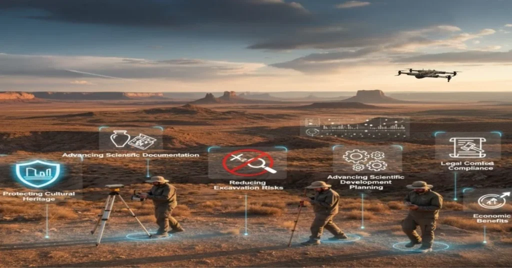
Key Benefits of Archaeological Surveys:
- Protecting Cultural Heritage: Identifies sites before development projects begin, preventing the accidental destruction of necessary historical resources through careful planning.
- Reducing Excavation Risks: By focusing on the most promising areas, this method minimizes wasted resources and avoids costly excavations of low-potential areas.
- Supporting Development Planning: Provides essential information for following environmental rules and managing land in a way that is beneficial for the economy and protects heritage.
- Advancing Scientific Documentation: Makes permanent records that allow for comparative research, hypothesis testing, and recording how cultures change over time.
- Legal Compliance: Follows the rules for protecting heritage that are required in many places around the world, which keeps the project on schedule and avoids penalties.
- Economic Benefits: Prevents costly project delays by identifying heritage issues early in planning processes, saving developers significant time and money.
Archaeological Types of Surveys
Knowing the various archaeological types of surveys allows the survey archeology teams to choose the most suitable method for their case. Every one of them reveals distinctive benefits according to particular research issues and the state of the environment.
The method of archaeological survey depends upon the terrain conditions, the type of vegetation, the time limitations, and the budget constraints.
Surface Survey (Field Walking)
Archaeologists carry out surveys of the surface systematically in a study area, and these surveys are known as field walking or surface surveys. Teams are searching for artifacts, ruins of buildings, and other signs of the presence of humans on the ground. This method of conducting archaeological field surveys is most suitable in locations where ground visibility is good.
Field walkers typically follow evenly spaced transects throughout the survey area. They gather or write down any cultural items they come across. Modern surface surveys use GPS technology to obtain exact positions and traditional observation.
Aerial and Drone-Based Survey
Archaeologists can now survey large areas in a whole new way through aerial surveys. Drones with high-resolution cameras take pictures from above that are very clear. These aerial drones can quickly cover large areas and find things that can’t be seen from the ground.
Drone technology enables survey archeology teams to reach remote areas without physical presence. Survey sites become easier to conduct when there are dense forests, steep slopes, and dangerous areas. From an aerial perspective, patterns in the landscape, cropmarks, and earthworks reveal the locations of buried buildings.
Geophysical Survey Methods
Geophysical surveys use special tools to detect buried archaeological features without excavation. These non-invasive methods measure physical properties like radar reflections, magnetism, and electrical resistance.
The method of archaeology used depends on the soil and the features being looked for:
- Ground-Penetrating Radar (GPR) sends radio waves into the ground and picks up signals from things that are buried.
- Magnetometry finds magnetic anomalies that were caused by things people did in the past, like burning or working with metal.
- Electrical resistivity finds features by looking at how they conduct electricity differently from the soil around them.
Geophysical methods supplement visual surveys by revealing subsurface archaeology. An archaeological survey that combines surface observation with geophysical prospecting can provide a thorough understanding of a site.
Subsurface Testing and Sampling
Subsurface testing involves a limited physical intervention to assess underground deposits. Archaeologists are employing shovel test pits, augers, and core samplers to investigate what is underground. This way of conducting an archaeological field survey provides direct evidence when the surface is challenging to see.
Test pits are small excavations that uncover the different layers of soil and the possible presence of artifacts. Augering is a method of soil core extraction that reveals both the depth and composition of the deposit. They represent the least invasive methods, serving as a bridge between complete excavation and non-invasive surveys in the field of archaeological surveying.
Reconnaissance vs. Detailed Survey
Reconnaissance surveys provide rapid, wide-ranging evaluations of large areas. These preliminary archaeological types of surveys identify places that are likely to have a lot of archaeological value. Detailed surveys look closely at smaller areas over shorter periods of time. Teams methodically collect all visible artifacts and meticulously document their details.
The choice between reconnaissance and a detailed survey is based on the goals of the project. Reconnaissance is often the first step in large-scale regional studies to identify sites. Subsequent detailed surveys concentrate on designated areas of interest, optimizing efficiency in archaeological survey programs.
What are the Methods Used in an Archaeological Survey?
There are different types of archaeological survey methods, depending on how they work and how intrusive they are. Researchers can make good survey plans that fit their specific goals by knowing how these methods work. The chosen method of archaeology must correspond with site conditions, research goals, budget limitations, and available time.
Non-Intrusive Survey Methods
Non-intrusive methods examine sites without disturbing archaeological deposits, which keeps them safe for future research that might use better methods. These approaches have gotten more advanced as technology has improved, giving survey archeology new abilities that were never possible before.
Primary Non-Intrusive Techniques:
- Aerial Mapping: Drones or planes are used to take pictures of the terrain with annotations of crop marks, shadow marks, and soil colors, which are indications of the locations of the buried structures that are not visible above ground.
- Geophysical Scanning: Magnetometers and ground-penetrating radar are used to detect unusual items under the ground and create maps of the subsoil without digging.
- Field Walking: Carefully walking around the areas surveyed to obtain a look at surface features and artifacts that provide ground-truth data confirming the results of remote sensing.
- Remote Sensing: It employs satellite images and LiDAR technology to monitor vast areas and penetrate the forest canopy to reveal the topography of the land.
- Photogrammetry: This method creates precise 3D models from multiple photos for comprehensive site documentation and analysis.
Intrusive Survey Methods
Among the different methods, intrusive surveys are the ones that necessitate the physical disruption of archaeological layers to provide conclusive subsurface data. Nevertheless, these methods are invasive, but they still present direct evidence, which is a priority when the non-invasive ones fail. The technique of archaeology equates the necessity of information with the need to keep the preserved items.
Primary Intrusive Techniques:
- Test Pits: Small excavation units (generally 50 cm square) that uncover the profile of the soil, artifacts, and features, showing the thickness of the deposits and the condition of their preservation.
- Core Drilling: This method obtains cylindrical soil samples from deeper layers for stratigraphic analysis and is suitable for sites that are deeply buried and for waterlogged deposits.
- Trial Trenches: These are extensive exploratory diggings that not only show the connections among the features and the general site layout but also provide more details about the below-ground layers than test pits do.
- Auger Sampling: A method of quick subsurface testing that determines the presence and depth of a deposit without full excavation, making it applicable for preliminary investigations.
Extensive vs Intensive Surveys
Comprehensive surveys examined large territories with remote sightings. This archaeological survey technique rapidly detects the overall distribution patterns of the sites. On the other hand, intensive surveys focus on more minor areas and make their observations at close range.
The groups thoroughly examine each square meter and gather all the artifacts that they can see. This archaeological practice gives us excellent data that exhibits the site’s layout and activity patterns with superb clarity.
The choice between extensive and intensive surveying in archaeology depends on the questions being asked. Regional settlement studies gain from comprehensive coverage. Site-specific investigations make use of intensive follow-up and a variety of techniques and methods. However, there are also cases of intentional combined use of both methods in a project.
Essential Tools and Equipment Used in Archaeological Field Survey
Today’s archaeology field survey requires quite a number of tools, including both classic and technologically advanced ones at the same time. Proper tool usage not only results in accurate data collection but also in the quick completion of the survey. By keeping these tools in mind, the surveying teams in archaeology can choose not only the right ones for their work but also the ones in accordance with their research goals.
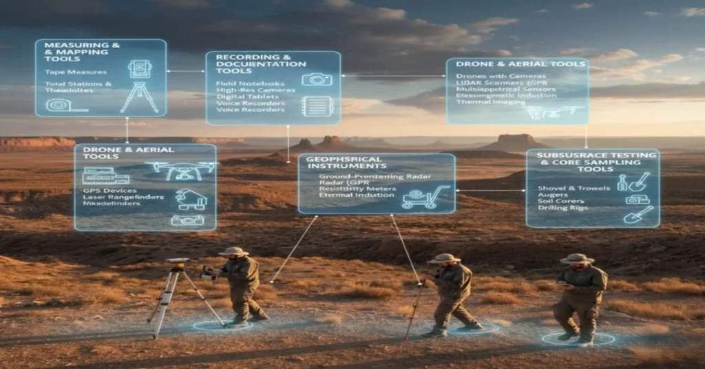
Measuring and Mapping Tools
- Tape measures: They are indispensable for measuring distances and marking grids, plus, they work perfectly in any weather conditions.
- Total stations and theodolites: Provide millimeter accuracy for three-dimensional mapping and topographic modeling.
- GPS devices: They can determine the location with up to one-centimeter precision; thus, survey data can be georeferenced in the right place and mixed up with GIS.
- Laser rangefinders: They are quick ways to get the distance, mainly when site documentation and feature mapping are done.
Recording and Documentation Tools
- Field notebooks: A mixture of handwritten notes, sketches, and contextual documents that contain information that digital systems might miss.
- High-resolution cameras: They supply pictures for photogrammetry, 3D modeling, and extensive documentation of the features.
- Digital Tablets: The process of entering data in real-time and instantly uploading it to the database significantly minimizes transcription errors.
- Voice Recorders: Hands-free recording of detailed observations is possible while conducting extensive survey work.
Drone and Aerial Tools
- Drones with cameras: They can take high-resolution aerial photographs that help create a map of large areas in a short time.
- LiDAR scanners: These produce highly accurate 3D representations of the terrain, cutting through the forest and revealing the regions that were previously covered by the trees.
- Multispectral Sensors: They reveal those wavelengths that are not seen by the naked eye through the changes in soil and plant marks that give away their position.
- Thermal Imaging: This technique identifies the sites of ancient civilizations by measuring heat changes that occur underneath the earth’s surface.
Geophysical Instruments (GPR, Gradiometer)
- Ground-Penetrating Radar (GPR): It is capable of transmitting and receiving electromagnetic waves, being able to locate not only the foundations but also walls and voids, giving accurate depth information for subsurface mapping.
- Magnetometers and gradiometers: Detect through the magnetic field variations caused by the presence of buried artifacts, kilns, fireplaces, and such human activities as metalwork or fire.
- Resistivity Meters: Investigate the variation of the electrical current in the walls and ditches of archaeological sites as compared to that in the surrounding soil.
- Electromagnetic Induction: It rapidly surveys the land for changes in soil conductivity that are indicative of the presence of buried structures across vast areas.
Subsurface Testing Tools
- Shovels and trowels: Allowing you to do the manual digging of test pits and remove soil for stratigraphic study cautiously. These tools are critical for different kinds of archeological survey teams doing intrusive testing.
- Augers: Extract cut-out cylindrical soil cores without the need to excavate the whole site. Manual augers can go through only the shallow layers, whereas motorized augers have a much longer reach.
Core Sampling Tools
- Soil corer: Take samples for analysis of the different layers and deposits below. In addition, it confirms the presence of artifacts, carbonized material, and sediment features in the regions with extremely thick or complicated layers.
- Drilling rigs: Take cores from greater depths for large projects, assist in the site formation process, and facilitate a more profound understanding of hidden horizons in archaeological research.
How to Conduct an Archaeological Survey (Step-by-Step)
The success of an archaeological survey depends on its systematic planning and execution as per professional standards. This whole process leads to total coverage and reliable records. The method of archaeology should follow best practices acknowledged by reputable archaeological professionals.
Step 1: Research, Planning, and Permissions
A field survey carried out in archaeology cannot do without background research as the primary supporting basis. A well-organized schedule not only saves time and resources but also guarantees significant outcomes.
- Research historical documents, maps, previous survey reports, and environmental data thoroughly.
- Prepare a comprehensive research design that specifies the objectives, methods, sampling strategies, and documentation procedures.
- Get the landowner’s consent and necessary permits/licenses before the beginning of the fieldwork to ensure compliance with the law.
- Bring together team members who have the needed skills and equipment for the chosen survey methods.
Step 2: Field Survey Execution
Field execution carries out your research plan in an orderly manner through systematic site investigation. Nevertheless, flexibility is still vital since circumstances might necessitate changing the methods used.
Systematic Walking and Observation:
- Do a traverse survey of the area by moving along the predetermined transects with regular spacing intervals
- Record the exact locations of observations using GPS devices for spatial analysis
- Systematically document all surface features, artifacts, and landscape characteristics.
Surface Collection and Mapping:
- This task will basically consist of collecting visible artifacts in compliance with predetermined collection protocols and research objectives.
- The locations of the artifacts will be documented using total stations, GPS, or grid systems for spatial patterning.
- Features will be photographed, and detailed field sketches will be created for future reference.
Subsurface Testing:
- Excavation of test pits or extraction of auger cores will be conducted systematically across the survey area.
- Stratigraphy, artifact presence, and feature indications will be recorded in standard formats.
- Samples for specialized analysis will be collected when deemed appropriate.
Geophysical and Remote Sensing:
- Perform the subsurface mapping comprehensively by the combination of Ground Penetrating Radar (GPR), magnetometry, and resistivity surveys.
- Drone surveys and aerial photography are the most effective methods for covering large areas quickly and efficiently. Keep data processing up to the point of revealing the features requiring subsequent inspections.
Step 3: Documentation and Mapping
Maintenance of proper records helps in the analysis, review, and preparation of different results and improves future research, too.
- The field notes should be kept to track all impressions, measurements, and findings carefully.
- Take pictures of the things that serve as a good visual representation of the site’s characteristics, conditions, and general situations.
- Use GIS to bring together geospatial data and generate detailed maps showing areas of the site.
- Fill out comprehensive site forms that include the location, features, artifacts, and assessment of importance.
Step 4: Analysis, Interpretation, and Reporting
The analysis uncovers archaeological understanding and suggestions of great importance through the unprocessed field data.
- It identifies the spatial configurations by discovering the locations of artifacts, looking at the distributions of features, and investigating the interactions between layers.
- Evaluate the worth and research possibilities of the location based on the criteria of evidence and preservation.
- Create and deliver the technical reports that comply with the most rigorous professional standards to detail the processes, results, and interpretations.
- Share knowledge and reports with the help of papers and presentations as a means of contributing to the progress of archaeology.
Challenges in Surveying an Archaeological Site
There are many challenges with archaeological survey work that affect the quality and coverage of the data. Researchers can come up with successful plans and realistic goals if they understand these problems. To do well in surveying in archaeology, you need to be able to adapt to different field conditions and get around both natural and man-made obstacles.
|
Challenge Category |
Specific Issues |
|
Environmental & Terrain |
Vegetation cover makes the field difficult to see; steep slopes make it challenging to navigate to places, wetlands make it challenging to survey, and stormy weather makes it difficult to remain safe. |
|
Technological Limitations |
Certain types of soil, high equipment costs, the need for technical knowledge, and challenges in data interpretation can affect the performance of instruments. |
|
Legal & Ethical |
Legal and ethical considerations include limitations on property access, cultural sensitivities that necessitate consultation, various laws protecting heritage, and the rights of indigenous people. |
|
Accessibility |
Remote areas that need a lot of planning, dangerous areas that make it challenging to do surveys, areas with little infrastructure, and areas where fighting is going on. |
|
Data Quality |
Post-depositional disturbances that change patterns, sampling biases that change results, sites that are too deep to be found, and problems with preservation. |
How Drones Improve Archaeological Surveying?
In the past decades, drone technology has changed the way archaeologists do surveys. These drones solve many of the problems that come with traditional surveys and create whole new research opportunities. Archaeologist survey teams are using drones more and more to gather data quickly and accurately that they couldn’t get by just walking around on the ground.
The use of drones in survey archeology is one of the most important technological advances in the past few decades. Drones solve real-world problems, like quickly mapping areas and accessing dangerous locations, which significantly improves the quality of data.
High-Resolution Mapping & 3D Models
- The system provides ultra-high-definition imagery with a resolution of 2 to 3 centimeters per pixel from suitable heights.
- Making use of photogrammetric techniques, accurate 3D topographic models are created with the precision of centimeters.
- Orthophotographs that are geometrically corrected allow for accurate measurements and professional cartography.
Better Site Accessibility
- Access and monitor hazardous or difficult ground areas, such as cliffs, thick bush, and collapsing zones, securely to prevent any injuries.
- Significantly cut down the amount of required logistical support for the remote site.
- Carefully survey places with political or security restrictions on access.
- Overcome barriers for surveying via traditional means that the ground survey cannot cross.
Non-Invasive Study of Heritage Sites
- No ground disturbance: sites kept completely intact for research in the future.
- Humans cannot damage fragile structures during the documentation process.
- Surveys that have an impact are allowed to be repeated, thus checking the site’s condition over time.
- Records of the sites done before excavation are complete, as are pre-disturbance records.
Cost-Effective Data Collection
- Consumer-grade drones offer professional-grade capabilities at lower prices.
- Field time has been reduced drastically, which means weeks of ground survey can now be done in just hours.
- Processing software that is free and open-source makes advanced analysis accessible to all.
- Having lower operational expenses allows for more frequent monitoring and documenting.
Real-Time Monitoring
- Utilize live video feeds to assess survey progress and promptly make any necessary adjustments.
- Quick data review enables adaptive survey strategies, identifying areas needing detailed investigation.
- Real-time imagery viewing engages the stakeholder and builds project support.
- Field decision-making and resource allocation benefit from the immediate feedback.
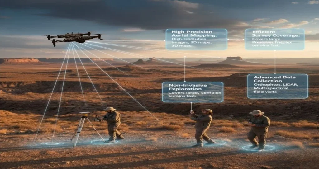
How Zenadrone 1000 Supports Archaeological Field Surveys?
The Zenadrone 1000 is a state-of-the-art drone that was made for professional use, such as archaeological field survey. This advanced drone has powerful hardware and innovative software that work together to make it work better. Archaeologist survey teams can use features that were specifically designed for harsh field conditions that consumer drones can’t handle.
The Zenadrone 1000 is different from consumer drones made for taking pictures for fun because it meets the needs of professional survey archaeology. Its strong build, long flight time, and advanced sensors make it perfect for large archaeological survey projects that need accuracy and dependability.
- High-Precision Aerial Mapping: Captures high-resolution images and 3D maps without disturbing the ground.
- Efficient Survey Coverage: Covers large or complex terrains faster than traditional walking surveys.
- Non-Invasive Exploration: Preserves fragile sites.
- Advanced Data Collection: Provides orthophotos, LiDAR scans, and multispectral imaging.
- Real-Time Monitoring and Reporting: Allows teams to monitor survey progress live.
- Cost and Time Efficiency: Reduces manpower and field visits, saving money and time.
Conclusion
Archaeological survey is the most essential part of modern heritage research and management around the world. Survey methods are changing quickly to meet modern challenges in protecting our cultural heritage, from traditional field walking to cutting-edge drone technology with AI.
Knowing the basics of archaeological surveys helps people in all fields make better decisions about how to protect cultural heritage. Technology changes the way we locate and record archaeological sites. Are you ready to improve your capabilities in archaeological field surveys? Find out how the Zenadrone 1000 can change the way you do surveys with its professional-grade aerial mapping, multispectral imaging, LiDAR compatibility, and ability to fly on its own.
FAQ:
How long does an archaeological survey take?
The size of the area, the method’s complexity, and the terrain’s conditions all affect the length of an archaeological survey. Hence, it can take only a few days for small sites, while it can take several field seasons, even years, for extensive regional surveys.
Who performs an archaeological survey?
Professional archaeologists with the proper academic training, field experience, and credentials do archaeological surveys through schools and universities. Depending on the type of archaeology used for the project, survey teams may include experts in geophysical techniques, drone operations, GIS analysis, and artifact identification.
What is a reconnaissance survey in archaeology?
Reconnaissance surveys make quick and rough evaluations of vast areas in a way that makes it possible to identify the most promising archaeological sites without the need for resource-consuming investigations.
Is an archaeological survey required before construction?
In many places, archaeological surveys are made mandatory by law before the start of any significant development project, and the environmental impact assessments typically have archaeological field surveys included among their components to find out the existence of heritage resources.
How accurate are geophysical methods?
The accuracy of geophysical methods is primarily influenced by soil conditions, instrument quality, operator skill, and feature characteristics, with GPR, under the best conditions, possibly pinpointing buried features within centimeters.
What is the best method of archaeology for new site discovery?
There is no one best way to do things, so modern archaeological survey projects use a mix of traditional field walking and cutting-edge technology to achieve the best results.
Contact Us
Thank you for your message. It has been sent.