


Topographic Survey Types, Process, and Benefits

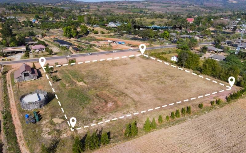
Topographic survey shows the shape and features of a piece of land. It includes natural features like hills, slopes, trees, and drain areas. It also shows man-made features such as buildings, fences, and roads. The survey focuses on land height and surface details, not property lines. Engineers and builders use this survey before starting construction.
It helps them plan where to place buildings, roads, and use. Surveyors collect data using equipment like GPS, measuring equipment, and drones. The survey is complete early in a project. It helps to finding problems before building begins. This saves time and money. Topographic surveys are also needed for work permits and approvals from government agencies. They play an important role in safe and smart land development.
Types of Topographic Surveys
A Topographic surveys are used for different Goals in land planning and development. Each type collects specific details based on the projects required. These surveys help planners, engineers, and builders to understand the land better. The information supports accurate design, safe construction, and rule compliance. Selecting the right survey method secures precise measurements and better decisions from planning through construction.
- Boundary Survey: A boundary survey shows where one property ends and another begins. It helps find the true corner of the land. Surveyors use property records, land markers, and on site checks to locate corners. This survey is important before buying and selling land. It is also used when building fences and settling property line problems with neighbors. Surveyors use tools like GPS, measuring tools, and sometimes drones to mark the boundaries correctly.
- Hydrographic Survey: A hydrographic survey measures land under water, such as rivers, lakes, and ocean floors. It helps with ship navigation, bridge building, ports, and dredging projects. Surveyors use GPS, sonar, and echo sounders to measure water depth and find underwater hazards. This survey supports coastal planning, flood control, and safe marine construction.
- ALTA Survey: An ALTA survey is used for commercial properties. It shows boundaries, easements, buildings, and access points. Banks, title companies, and lawyers require it before property sales and financing. It follows national standards and combines boundary data, land features, and legal records to confirm ownership and land use rights.
- As-Built Survey: An As-built survey shows what was actually built after construction is finished. It records the main location of buildings and utilities. This survey checks if the project matches approved plans. It helps builder’s correct mistakes and improve future projects.
- Site Survey: A site survey collects important land information before design and construction starts. It includes slopes, vegetation, utilities, access points, and possible hazards. Engineers use this data to plan drainage, foundations, parking, and walkways. It is usually the first step in any building project.
- Geodetic Survey: Measures very large areas of land using Earth shape and global coordinates. It uses satellites and GPS to create accurate reference points. These surveys support mapping, aviation, telecommunications, and environmental monitoring.
- Topographic Land Survey: A topographic land survey measures land shape, elevation, slopes, trees, and buildings. It helps plan roads, drainage, and building layouts. Surveyors use tools like drones and GPS collect accurate data. This survey helps find problems early and reduces construction delays.
- Topographic Survey Mapping: Topographic survey mapping turns land data into detailed maps. These maps show elevation, contours, vegetation, and structures. Engineers use them to plan excavation, water flow, and design changes. Modern tools like drones and scanners improve accuracy and save time.
The Importance of Topographic Surveys
Topographic surveys are invaluable in land-use decisions in construction, development, law, and environmental planning. Such surveys reveal a land’s physical characteristics, helping professionals better define risks and align their designs to site conditions. Each industry depends on accurate and up-to-date topographic data to make informed decisions that support safety, compliance, and cost-efficiency.
In Construction: Accurate Planning and Design
A topographic survey for construction provides essential elevation, slope, and surface data patterns that would help with grading, drainage, and site planning. Engineers use this data to create stable foundation designs that adapt to land contours and minimize environmental disruption. Builders reduce delays and redesigns by ensuring the proposed structure aligns with actual terrain and on-site conditions.
Construction teams utilize surveying instruments like total stations, GNSS receivers, or drones to gather field data and ease the modelling process. Projects without a careful and detailed topographic survey are extremely at risk for unexpected delays and surprises that usually increase time, labor, and costs.
For Land Development: Assessing and Understanding Terrain
Knowledge about the land features assists planners in using and demarcating the property in land development survey projects. Correct contour lines will influence drainage design, infrastructure layout, and zoning for commercial and residential purposes. Developers will use land surveying services to determine slope, water flow, and buildable area before construction.
Early identification of steep slopes or unstable soils protects investment and eases the path to regulatory approval. A topographic map indicates where roads, buildings, and utilities are, with less risk. Using contour mapping, planners see how the land rises and falls, influencing construction feasibility and cost.
In Legal Disputes: Proving Boundaries and Land Usage
For the surveyor, clear, visual, and factual evidence will sustain the legal argument supported by historical records, terrain features, and measurements. Topographical surveys show how the land has been utilized or altered over time, while boundary surveys confirm ownership lines.
Courts consider topographical data objective proof supporting a just resolution of land disputes. Elevation mapping helps lawyers and landowners show erosional changes in terrain that support or contradict conflicting claims of land use. Surveying professionals map the nitty-gritty, so those grays are much more transparent, thus reducing the chances of extended litigation.
Environmental and Planning Applications: Land Conservation and Studies
The cost of topographic surveys is a better investment when planning parks, nature reserves, or developments close to sensitive habitats. Data helps identify areas that are essential for environmental compliance, such as:
- Water runoff paths
- Erosion risks
- Flood zones
Using surveying instruments, scientists can measure the changes in topography due to natural events, human activity, or climate change. Topographic maps also assist habitat conservation, identifying regions needing protection and limited use. Planners determine where vegetation can thrive or infrastructure might harm ecosystems by layering elevation mapping and soil data.
Topographic Surveying Equipment & Tools
Such tools enhance the swiftness, precision, and efficacy of professionals undertaking site topographic surveys and mapping terrain characteristics. A site topographic survey uses innovative technologies to collect comprehensive land data.
1. GPS and Total Stations - Essential Tools for Measurement Accuracy
GPS surveying permits accurate coordinate identification via satellite signals even in rugged terrain and large project areas. Total stations allow professionals to measure angles and distances, enabling reliable spatial data collection on relevant land points, structures, and elevations.
Meticulous reference points for topographic land surveys are essential in the base maps, particularly for design infrastructure or zoning purposes. Surveyors frequently combine the two to confirm control points and guarantee uniformity throughout sizable mapping areas.
Reference points in construction surveying require accuracy to prevent grading errors, misalignment of structures, or noncompliance with regulations. GPS and total station survey data support creating topographic maps, aligning projects, and verifying boundaries. Using both instruments leaves a complete and defensible data set available for engineering, legal, and environmental purposes.
2. LIDAR - Used for Precise Elevation Data
LIDAR surveying captures millions of data points each second to generate dense elevation models of Earth, vegetation, and man-made structures. The use of LIDAR in dense vegetation environments and areas with complex elevation changes is subject to limitations. Surveyors will mount LIDAR equipment on aircraft, vehicles, and tripods, depending upon the scales involved and the resolution sought.
In topographic land survey work, LIDAR cuts downfield time while increasing the accuracy and safety of measurements in difficult-to-access situations. With GPS data, LIDAR enhances the contour detail, assisting major planning decisions in a topographic map.
3. Drones for Topographic Surveys - How Drones Are Transforming Surveying
Surveying drones yield high-resolution aerial imagery and elevation quickly and are thus deemed best for large sites or dangerous terrain. They reduce labor costs and eliminate safety risks associated with rough, sloped, or obstructed land surfaces. Drones capture georeferenced imagery used for photogrammetry, which allows the production of 2D maps and 3D terrain models.
Drones accelerate workflows for a site topographic survey and allow faster access to reliable visual and geospatial information. With LIDAR surveying, drones collect data at unprecedented speed and real-time coverage. Drone imagery helps engineers understand terrain context, essential in surveying for construction and environmental studies.
4. Leveling Instruments - Ensuring Elevation Accuracy
Leveling instruments supply levels or vertical data for slope, drainage planning, or construction grading analysis. Manual and digital levels, based upon horizontal sight lines at the staff readings, by definition, measure height differences between land points. Such instruments allow for producing cross-sections and contour lines for any topographic land survey.
Leveling is often part of GPS surveying setups, acting as a ground check to ensure vertical accuracy across terrain. Contractors design foundations’ stability, building code compliance, and flood zone management based on the given elevations information. In analyzing topographic survey data, leveling verifies the terrain heights for consistent design application.

How Topographic Surveys Work The Process
Understanding how topographic surveys work helps teams plan better and avoid extra costs. The process happens in four main steps.
Phase 1: Planning and Site Check: Before the survey starts, surveyors study the land and talk with the client. They check how easy it is to access the site, how rough the land is, and if there are any safety risks. They also confirm boundaries, set control points, and coordinate with engineers or architects. This planning helps the survey run smoothly and avoids mistakes later.
Phase 2: Data Collection: Surveyors collect land data on-site using tools like GPS, total stations, and drones. They measure elevation, terrain, and visible land features. Field crews record and check the data to make sure it is accurate.
Phase 3: Data Processing: The collected data is uploaded into software. Surveyors create maps, contours, and 2D or 3D models. Errors are removed so the maps match real land conditions.
Phase 4: Final Report: The final survey report includes accurate maps and data used for planning, design, and construction. This process helps reduce errors and saves time and money during development projects.
How to Budget for a Topographic Survey:
The cost of a topographic survey depends on several factors. Larger land areas usually cost more to survey. Land with trees, hills, or buildings also takes more time and effort. In these cases, surveyors may use equipment like GPS, drones, 3D scanning, and LiDAR. These equipment improve accuracy but can increase the total cost.
Different types of surveys have different prices. Boundary surveys usually cost less because they cover smaller areas. Geodetic surveys cost more because they measure large areas and need high accuracy. ALTA and as-built surveys are often more expensive because they include legal details and detailed reports. Hydrographic surveys cost more due to boats and sonar equipment.
To plan your budget, ask for quotes from licensed surveyors. Clearly explain your project needs and survey purpose. Choose accuracy over the lowest price to avoid costly mistakes later. Always plan extra funds for large or hard-to-reach sites.
Benefits of Topographic Surveys for Construction and Development
Topographic surveys help make building and land projects safer and easier. They provide clear information about the land before work begins. This helps teams plan better and avoid problems later.
- Better Planning and Decisions: A topographic survey shows the shape of the land. It helps builders choose the best place for buildings, roads, and utilities. Architects and engineers use this data to work around hills, slopes, and other land features.
- Meeting Rules and Regulations: Many cities and local offices require topographic surveys for permits. These surveys show land size, elevation, and boundaries. This helps projects follow zoning laws and environmental rules.
- Reducing Risks and Costs: Topographic surveys help find flood areas, steep slopes, and other risks early. Finding problems before building starts saves time and money. It also helps create safer and stronger structures.
Topographic Survey Mapping: What You Need to Know
Topographical survey mapping provides visuals of the terrain in detail through representation: symbols, lines, and elevations, for various professional applications. Builders, engineers, and planners rely on these maps to interpret the land features and make informed design decisions. Frequently, surveying instruments, GPS surveying, and occasionally cutting-edge technology like surveying drones function to create them.
What is a Topographic Map?: Explanation and Types of Topographic Maps
Contractors often obtain land development survey data to assess the terrain challenges before commencing work on a new site. Topographic maps assist in budgeting and completing on time through:
- Grading
- Excavation planning
- Foundation layout
Elevation mapping minimizes surrounding environmental disturbance and increases construction accuracy from beginning to end.
How Topographic Maps Are Used in Construction and Land Development
Contractors access land development survey data to understand terrain obstacles before construction opens at a particular site. Topography maps help in grading, excavation planning, and foundation layout because they direct a team toward budgetary and timing accuracy. Topographic maps minimize disturbance to the surrounding environment and enhance constructional accuracy throughout all stages of development.
Types of Topographic Maps: Contour Lines, Spot Elevations and More
Most maps contain contour lines at regular intervals, indicating elevation changes across the land surface. Supplementary features include:
- Spot elevations
- Water bodies
- Wooded areas
- Existing structures
Different kinds of maps apply depending on the goal of construction, environmental research, or land development.
How to Read a Topographic Map: Basics for Non-Surveyors
It’s all about contour lines:
- Closer lines mean steeper places
- Further lines apart indicates flatter landscapes.
Interpret real distance and elevation using map legends and scale. With such learning, laymen can utilize topography to make decisions in real-life situations.

Choosing the Right Topographic Surveying Company
Picking the right partner for topographic surveying ensures accurate land information, smooth planning, and minimized construction risks. A provider with a good reputation upholds professional standards and delivers comprehensive results promptly and within budget constraints. You require a team with surveying experience covering land use regulations and site-specific problems.
Why Expertise Matters: Ensuring Accurate Data and Reliable Results
Surveying errors may lead to process delays, cause legal troubles, incite anxiety for costly reworking, or any of the above. Experienced professionals use advanced tools to deliver reliable measurements for engineering or land surveying services. Select a group with years of practical experience and a track record of satisfied clients on related projects.
What to Look for in a Surveying Service: Credentials, Equipment, and Experience
It’s essential to check for certifications, licenses, and evidence of topographic surveys completed across various types and conditions of property. Current equipment, such as drones, GPS systems, and 3D scanners, indicates the use of technology to achieve operational efficiencies. Confirm also that their process has quality control steps before final delivery.
How to Get a Quote for Your Topographic Survey: Step-by-Step Guide
Start by sharing your site address, project scope, and timeline. Then, the company may visit the site or review plans. Expect an estimate based on complexity, property size, and topographic survey requirements.
Contact Us for Your Topographic Surveying Needs!
Did you plan a project? ZenaDrone offers precise topographic surveying services designed around your goals and budget.
We combine technology, skill, and commitment to provide dependable land surveying services across residential, commercial, or industrial sites.
Get started today! You can request a free quote or ask questions about our process. Your project deserves clarity, precision, and professional insight. Let’s map your success! Reach out now to discuss your topographic survey needs.
Contact Us
Thank you for your message. It has been sent.