


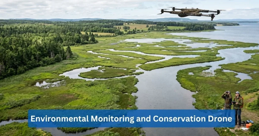
Environmental Monitoring Drones: Protecting Nature Through Aerial Technology
Tracking ecosystem health and pollution levels can be arduous, further emphasizing that the current state of environmental monitoring needs improvement. When it comes to real-time environmental data collection initiatives, conservation drone technology is a primary conservation technology solution.
Modern organizations have started to adopt environmental monitoring and conservation drones for such tasks in order to provide real-time data, improve ecosystem management, support wildlife protection, and enable cost-effective environmental assessments.
In this blog, there will be discussions pertaining to how these unmanned aerial vehicles (UAVs) can be used in environmental monitoring and conservation cases that are deemed sustainable.
Environmental Monitoring and Conservation
Most national agencies and research institutions refer to environmental monitoring and conservation as the systematic tracking of ecological health in order to prevent habitat damage and drive sustainable practices. As of late, diverse global ecosystems have been facing growing environmental challenges such as accelerating climate shifts, rapid habitat loss, and expanding industrial development. These environmental challenges can negatively affect biodiversity and even cause localized deforestation and alteration of natural water systems.
The escalating crisis for the environment demands proactive strategies that can help local efforts meet standard goals of monitoring and conservation. With that, real-time environmental data can be alleviated by providing information that tracks rapidly shifting ecological variables as they happen. Immediate measurements lead to responsive risk-mitigation pipelines, making it easier to resolve ecological issues before they worsen.
In relation to real-time environmental data, conservation technology solutions like environmental monitoring and conservation drones have been consistently used for their live aerial data. Drone environmental monitoring can capture high-resolution imagery and topographical data that assist research institutions with autonomous remote sensing instruments. Unlike traditional methods that can have human tracking errors and require expensive fieldwork hours, UAV environmental monitoring is cost-effective and offers a technical advantage in providing spatial coverage.
Why Drones Are Essential for Environmental Monitoring
As mentioned above, environmental monitoring and conservation drones are utilized for their advanced tracking and responding to ecological changes. Modern organizations deem it essential to deploy environmental monitoring drones for reasons such as:
- Rapid Data Collection Capabilities: Drones are equipped with rapid data collection capabilities that allow faster gathering, compiling, and storing spatial metrics. Rapid data collection capabilities are features that enable environmental monitoring and conservation drones to sweep hundreds of hectares in a single operational flight, highlighting their efficiency, thus making it essential.
- Access to Remote and Difficult Terrains: In addition, environmental monitoring and conservation drones are essential for their access to remote and difficult terrains. These UAVs are capable of navigating and documenting dangerous areas, eliminating the need for human fieldwork. Environmental data collection is safer when utilizing advanced drones for risky operations.
- Cost-effective Environmental Assessments: Another aspect of these drones is their cost-effective environmental assessments. Environmental monitoring and conservation drones involve operational budgets, personnel hours, and hardware expenditures. All of these environmental assessments significantly minimize logistical expenses from traditional excursions and can overall improve budget efficiency.
- Improved Accuracy and Coverage: These environmental monitoring and conservation drones are engineered to have better accuracy and coverage compared to traditional methods of environmental monitoring and conservation. Drone environmental monitoring leads to the simultaneous capture of overlapping data across thousands of acres, enhancing a comprehensive data foundation.
- Real-time Environmental Intelligence: Environmental monitoring drones are essential as they provide real-time environmental intelligence. Modern drones are built with immediate processing and broadcasting of live sensory data that can convert it into actionable digital alerts. This allows insights that help facilitate immediate emergency responses.
Wildlife Monitoring and Protection
Other than natural resources, these environmental monitoring and conservation drones can also assist research teams with wildlife monitoring and protection. Wildlife monitoring drones are capable of the following:
- Tracking Endangered Species: Locating and identifying rare or threatened wildlife populations can be easier when deploying wildlife monitoring drones. Tracking endangered species with these drones can help conservation teams in distributing medical aid or establishing localized protection zones.
- Monitoring Animal Migration Patterns: Animal migration refers to the seasonal movements of animal herds, bird flocks, and marine life. The patterns of such can be monitored through wildlife monitoring drones that are built to analyze migration pathways in order to establish dynamic wildlife corridors.
- Anti-poaching Surveillance Operations: Wildlife monitoring drones can also act as anti-poaching surveillance operations, specifically as a consistent watch on wildlife reserves against unauthorized human intrusions and illegal hunting activities. Furthermore, aerial policing can be done continuously with the help of environmental surveillance solutions, which will help protect endangered animals.
- Habitat Assessment and Protection: Additionally, wildlife monitoring drones can also be utilized for habitat assessment and protection. This includes the density of the structure, the amount of water available, and the biological health of the structure as a whole. Continual habitat assessment and protection ensure continual landscape auditing, which can inform landscape restoration through data.
- Minimizing Human Disturbance during Monitoring: Wildlife monitoring drones minimize human disturbance. A drone is used to decrease the need for human involvement, as mentioned above. The drones can capture vital ecological data without disrupting animals’ natural behaviors, stress levels, or feeding patterns.
Forest Monitoring and Conservation
Environmental monitoring and conservation drones are also practical to deploy in forest monitoring and conservation operations. Field researchers can utilize these non-invasive environmental monitoring drones for specific tasks like:
- Deforestation Detection and Prevention: Conservation drone technology is particularly necessary for deforestation detection and prevention. Modern drones are capable of continuous scanning remote boundaries for unauthorized tree removal or road carving. Aerial tracking can help in stopping illegal logging operations early.
- Forest Health Assessments: To add, drone environmental monitoring can be utilized for forest health assessment, which involves identifying early signs of bug infestations, drought stress, or disease across tree stands. Forest health assessments ensure that infested tree clusters are safely quarantined and treated.
- Wildfire Detection and Early Warning Systems: Environmental monitoring drones are built with predictive wildfire tracking, which is highly useful for wildfire detection. Along with early warning systems, drones can identify hotspots, lightning strikes, or rising thermal signatures. It’s also equipped with infrared cameras capable of monitoring timberlands even in the dark.
- Carbon Stock Monitoring: UAV environmental monitoring is also associated with carbon stock monitoring, which involves measuring tree heights, trunk diameters, and overall forest biomass. Carbon stock monitoring through drones is increasingly using airborne LiDAR (Light Detection and Ranging) payloads for accurate models of a forest’s structure.
- Reforestation Project Management: Conservation technology solutions, such as drones, also take part in reforestation project management. Drones are able to restore degraded landscapes by tracking seedling survival rates and planting biodegradable seed pods. Automated planting is faster in terms of ecosystem recovery.
Water Resource Monitoring
Ecosystem monitoring drones can also be deployed near bodies of water in order to conduct water resource monitoring. Specifically, environmental monitoring and conservation drones can be used for the following cases:
- Water Quality Assessments: Drones are capable of measuring physical, chemical, and biological characteristics of water resources. Water quality assessments involve using a UAV’s specialized multispectral sensors to capture variations in water surface reflectance.
- Wetland Conservation Monitoring: Additionally, drones can also conduct wetland conservation monitoring. Drones are used by teams to create maps of sensitive areas where land meets water. Wetlands are important and can be protected by consistent mapping of these water resources, which helps identify early signs of drainage failure at the local level.
- River and Watershed Analysis: Analyzing rivers and watersheds involves evaluating their natural flow mechanics, sediment transport patterns, and bank erosion stability. Drones are most helpful in this specific analysis, since they provide three-dimensional photogrammetry and airborne LiDAR payloads that can build precise elevation models of a river’s path.
- Detection of Pollution Sources: Environmental monitoring and conservation drones can also be used for detecting pollution sources. These UAVs are designed to track distinct thermal and chemical anomalies back to their specific source, as their infrared cameras make it easier to identify the precise pollution source.
- Coastal Ecosystem Management: When it comes to coastal ecosystem management, conservation drone technology can also be utilized with its high-resolution aerial mapping that allows agencies to replace manual shoreline walks with a highly disciplined water management framework. This ensures that chemical runoff, wetland shrinkage, and shoreline erosion are identified and analyzed before issues get worse.
Climate Change and Ecosystem Monitoring
Drone environmental monitoring is also applicable for climate change and ecosystem monitoring. Specialized UAVs have aerial mapping platforms that can track and respond to ecological shifts caused by global warming. These specialized drones can also support operations such as:
- Climate Impact Assessments: Modern drones are engineered to analyze rising global temperatures and altered precipitation loops. Environmental data collection involves mapping physical indicators in order to have an aerial assessment of quantified structural habitat degradation.
- Biodiversity Monitoring Programs: This specific case of biodiversity monitoring programs utilizes drones for cataloging the variety, abundance, and spatial distribution of distinct plant and animal species. Wildlife monitoring drones can map multi-species interactions and populations, which protects biological variety and can help identify early signs of species decline or invasive species encroachment.
- Habitat Change Detection: Ecosystem monitoring drones are built to also detect habitat change, particularly in identifying and measuring physical transformations in land cover, vegetation structure, and shoreline boundaries. Drones can be used for habitat change detection, as they provide a consistent spatial overlay that intercepts environmental threats early.
- Environmental Risk Assessments: In terms of environmental risk assessments, most teams recognize how drones are capable of identifying and analyzing latent natural hazards. Environmental surveillance solutions such as infrared sensors and LiDAR payloads can help in evaluating terrain stability and optimizing emergency mitigation plans.
- Long-term Ecological Studies: Most importantly, there are the long-term ecological studies, which can be provided with data gathered from environmental monitoring and conservation drones. A systematic collection of standardized environmental data contributed by drones can help global scientists in building mathematically sound predictive models of future ecosystem shifts.
Technologies Powering Conservation Drone Operations
After learning how modern drones are being utilized in environmental monitoring and conversion cases, it’s also best to understand how they work. There is a wide variety of technologies that power conservation drone operations, which can be found below:
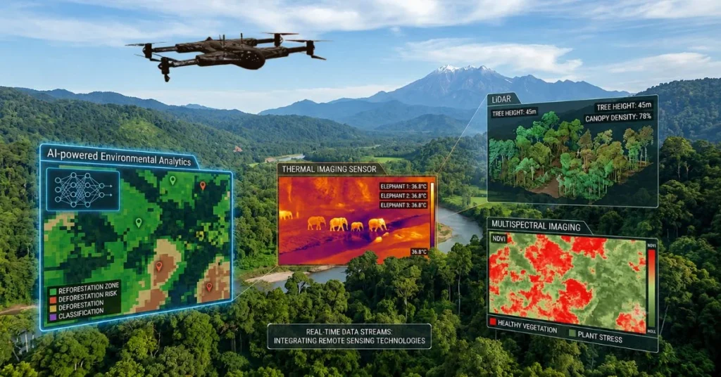
- AI-powered Environmental Analytics: Environmental monitoring and conservation drones are equipped with AI-powered environmental analytics that integrate machine-learning algorithms and computer vision models. With this technology, drones are able to evaluate massive geospatial data layers automatically.
- Thermal Imaging for Wildlife Monitoring: Another technology drones have is thermal imaging for wildlife monitoring. UAV environmental monitoring uses specialized long-wave infrared sensors that are capable of capturing the heat signatures emitted by living organisms and landforms.
- LiDAR for Ecosystem Mapping: Ecosystem mapping is best done with drones that are built with LiDAR sensors. Advanced drones have active remote sensing that enables calculation of exact distances based on the light’s return time, which can generate three-dimensional coordinate point clouds of structural features.
- Multispectral Imaging for Vegetation Analysis: In addition, environmental monitoring drones can also analyze the vegetation from multispectral imaging. This particular technology involves capturing visual data across specific, targeted wavelengths of the electromagnetic spectrum. With that, teams can measure how healthy and how stressed plant tissues are.
- Remote Sensing Technologies: The last technology that drones have that is necessary for environmental monitoring and conversion is the remote sensing technologies. Remote sensing for conservation includes data-gathering instruments for detecting, measuring, and recording physical characteristics of an area.
Benefits of Drone-Based Environmental Monitoring
Discovering the different ways drones can be used for environmental monitoring and conversion, and the various technologies that are utilized in doing so, has brought attention to the advantages of using drones. Here are the benefits of drone-based environmental monitoring:
- Enhanced Operational Efficiency: Environmental monitoring and conservation drones enhance operational efficiency, as they streamline the deployment of data tools to capture vast environmental insights faster.
- Reduced Survey Costs: UAV environmental monitoring also reduces survey costs. Since drones minimize the financial expenditures required to gather accurate spatial and environmental data, they replace expensive traditional monitoring assets.
- Improved Environmental Decision-making: Drones also improve environmental decision-making, as they can be used to help teams develop viable management plans based on science, and to gather objective, high-density data that can be used to develop these plans.
- Increased Safety for Field Teams: Modern drones help field teams to make better use of the day, operating safely and in the field. Drone environmental monitoring mitigates occupational hazards and physical risks by reducing human exposure to dangerous and risky locations.
- Scalable Conservation Programs: Conservation technology solutions indicate that there are scalable conservation programs, which refer to initiatives that are designed to expand their geographical scope and impact. Having drones monitor the footprint from localized plots to entire regional watersheds or mountain ranges makes it easier to create such conservation programs.
Future of Environmental Monitoring
Understanding how these environmental monitoring and conservation drones work in diverse situations leads to the opportunity of more methods in utilizing UAVs, such as autonomous conservation drone operations that are self-navigating, and deployment of drones that execute surveying missions without constant human intervention.
AI-driven ecosystem management is also imminent, as it integrates machine learning and computer vision with aerial data in order to classify habitats, detect anomalies, and track ecological shifts. Real-time environmental intelligence platforms refer to data systems that instantly process and visualize spatial data streamed directly from active conservation drone technology.
Moreover, smart conservation initiatives are also to be expected with how ecological protection frameworks embed advanced drone technologies. Lastly, there is the expansion of sustainable drone programs worldwide, which is the global scaling and integration of standardized aerial monitoring frameworks.
Conclusion
Modern organizations and teams that have adopted environmental monitoring and conservation drones recognize how it is faster, safer, and more precise when it comes to field data gathering. The growing role of UAVs in environmental protection is evident, considering that they are persistent and non-invasive for legally protecting geographies.
Technology-driven sustainability efforts are highly significant for advanced hardware and ecological science, especially in the long term. With that, environmental monitoring innovation has shed light on more future opportunities that lead to engineering advancements that will expand the capabilities of field research.
FAQ Questions
What is environmental monitoring and conservation?
Environmental monitoring and conservation refers to the practice of measuring, tracking, and analyzing environmental parameters in order to protect ecosystems and sustainably manage natural resources from degradation.
How are drones used in environmental monitoring?
Drones are used in environmental monitoring to capture high-resolution imagery and sensor data, allowing researchers to track habitat changes, monitor land use, and detect environmental threats in real time.
What are the benefits of drones for wildlife conservation?
Drones for wildlife conservation offer a non-invasive way to survey animal populations, track migrations, and map habitats without disturbing wildlife.
How do drones help monitor forests and ecosystems?
Drones can help monitor forests and ecosystems through specialized cameras that can assess canopy density, detect early signs of tree disease, calculate biomass, and map the boundaries of forest degradation or wildfire damage.
Can drones be used for water quality monitoring?
Yes. Drones can be used for water quality monitoring through multispectral sensors that can measure surface turbidity, chlorophyll levels, and algal blooms. At the same time, specialized custom units can physically collect water samples from remote water bodies for laboratory analysis.
What technologies power environmental monitoring drones?
Environmental monitoring drones are powered by AI-powered environmental analytics, thermal imaging for wildlife monitoring, LiDAR for ecosystem mapping, multispectral imaging for vegetation analysis, and remote sensing technologies.
How do drones support climate change research?
Drones can support climate change research by providing precise local metrics on melting glaciers, coastal erosion patterns, and shifting vegetation zones.
Are drones more cost-effective than traditional environmental surveys?
Yes. Drones significantly reduce operational costs, labor hours, and safety risks by replacing manned aircraft rentals and intensive, multi-week ground-based field surveys with rapid, repeatable automated flights.
What role does AI play in environmental monitoring and conservation?
AI processes large volumes of drone data automatically, utilizing computer vision models to count wildlife populations, flag illegal logging, and identify invasive species much faster than manual review.
How are drones helping protect endangered species?
Drones help protect endangered species by providing anti-poaching surveillance in protected reserves, locating highly camouflaged or nocturnal animals via thermal signatures, and mapping critical habitats to ensure targeted protection efforts.
Contact Us
Thank you for your message. It has been sent.