


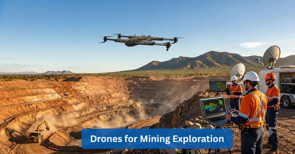
Drones for Mining Exploration: Transforming Modern Mining Operations
Improvements, reduction of cost, and maintaining higher safety standards in the industry of mining is growing pressure since it has to meet the global demand for minerals and raw materials. Companies are seeking innovative technologies that can streamline operations as well as deliver accurate data faster than traditional methods. This is because of the fact that mining projects are becoming more complex and geographically dispersed. One technology that has entered to change the game is drone technology. Also known as unmanned aerial vehicles (UAVs), these are transforming the way mining companies survey their sites, monitor their assets, inspect infrastructure, and collect geospatial information.
Drones’ ability to capture high-quality data rapidly while minimizing the risks to personnel is indeed an indication that they are an essential tool across the mining cycle. Drones for mining exploration nowadays are helping organizations make and execute decisions that are smarter and more efficient. They are a big help because they are responsible for accurate mapping, real-time monitoring, and also advanced analytics. From the first stage of mineral exploration to active mine management and planning for rehabilitation, drones are creating fresh and new opportunities for efficiency and innovation.
This blog explores how drones are transforming mining operations, the technologies driving their adoption, and their long-term impact on the industry.
The Shift Toward Smarter Mining
There is a major digital shift that’s happening now in the mining industry because companies are adopting modern technologies to improve the way they operate. Innovations are becoming increasingly common across mining activities.
These innovations include:
- AI (artificial intelligence)
- Automation
- Cloud computing
- Remote sensing
The mentioned technologies are useful, especially in helping organizations work more efficiently, making smarter and better decisions, enhancing safety, and retaining competitiveness in an industry that’s rapidly evolving.
Traditional inspections and surveying of mine sites depend heavily on manual labor, ground crews, and expensive equipment. Both processes often require substantial time and resources in order to be done. What’s making it difficult is the exposure of workers to potentially hazardous environments. It would take days or even weeks for the data collection results to be ready for analysis, compromising both safety and efficiency. Modern drone-based mining solutions have fundamentally changed this workflow. Drones have the ability to collect vast amounts of accurate data within hours. They provide mining teams with near real-time insights into site conditions and operational performance.
Many professionals or even you, might ask how drones are used in mining and the answer is simple. It just spans a wide range of applications, including aerial mapping, stockpile measurement, environmental monitoring, inspections of infrastructure, safety assessments, and support in exploration. The use of drones in the mining industry has made faster decision-making more possible by providing stakeholders with timely information. In addition, managers can identify if there are challenges to deal with as early as possible, monitor the progress of the project more effectively, and allocate resources with greater confidence.
The growth of drones’ impact on mining is clearly linked to industry’s growing investment in aerial intelligence systems that are designed to improve productivity and lessen the uncertainties when doing the operations.
Unlocking Better Visibility Across Mining Sites
The best thing to remember about mining is how it usually occurs in places that can be difficult to assess, especially if the assessment is done with the use of traditional survey techniques. In addition, obtaining a comprehensive understanding of a certain terrain’s condition is critical for exploration, planning, and resource management.
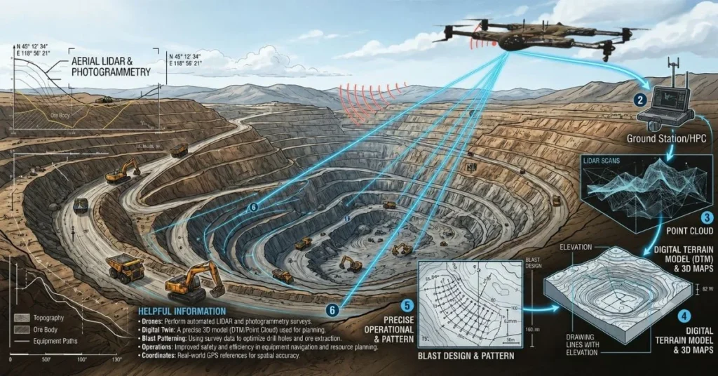
Drones for mining exploration provide a visibility that’s considered unparalleled across large mining sites through high-resolution aerial imaging and advanced mapping technologies. Additionally, drones can capture detailed data because it is equipped with sensors that we mostly deem as sophisticated due to its material and level of functionality. The detailed data captured helps geologists and engineers to evaluate the characteristics of a terrain and identify areas of interest.
A drone mining survey allows a quick generation of topographic maps, orthomosaic imagery, and digital elevation models. These outputs provide information that’s valuable enough for mine planning, designs for roads, drainage analysis, and development of infrastructure. In mineral exploration projects, aerial mining surveys help identify geological features that may indicate the presence of valuable resources. This information supports more targeted exploration efforts and reduces the time required to assess prospective sites.
The use of mining drones in analyses also helps the organization to compare the site’s historical and current conditions. Through this, teams can monitor if there are changes over time and also improve the accuracy of each plan they want to establish. Informed decisions are more easily made, at the same time, while simultaneously optimizing exploration and development strategies.
Reaching Areas That Were Previously Difficult to Access
Accessing locations that may be dangerous, remote, or otherwise difficult for personnel to reach is one of the most significant advantages of drone technology. As usual, mining environments contain high-risk zones such as steep slopes, unstable pit walls, underground tunnels, and active blasting areas. Considering its state, sending workers into these areas to perform inspections can be dangerous for their safety and might also cause operational disruptions. Many of these challenges can be lessened or eliminated by drones for mining exploration by allowing operators to conduct inspections remotely. Drones can safely fly over open pits, navigate in confined spaces, and capture detailed imagery without assigning someone to do it in the actual area.
Underground drone mapping has become a particularly valuable part of modern mining operations. Specialized drones are equipped with systems that would help it avoid obstacles as well as advanced sensors that would make it navigate underground places where GPS signals aren’t available. These systems are considered conducive for underground mine inspections because they generate accurate 3D models of tunnels, slopes, and other subterranean structures. The data collected helps engineers assess stability, identify hazards, and plan future development activities.
Drones for stope mining are increasingly used to inspect underground voids and assess conditions in areas that may be unsafe or inaccessible for personnel. In mining industry applications, drone inspection also extends to conveyor systems, processing facilities, storage areas, and critical infrastructure. Before, inspections once required shutdowns or extensive manual effort but now, it can be completed more efficiently with the help of UAV mining operations.
Improving Accuracy without Slowing Operations
It is essential to consider data accuracy if the goal is a successful mining operation because when inaccurate measurements are made, it can affect things that are important to be met like the planning of the project, resource estimates, the efficiency of the operations, and profitability.
Drone technology delivers datasets that are highly accurate while at the same time, minimizing disruption to daily activities. Modern mining inspection drones make use of sensors that are advanced to be able to capture detailed imagery and geospatial information with exceptional precision.
LiDAR drone mining systems are widely used for highly accurate terrain mapping. This technology uses laser pulses to measure distances and generate highly detailed 3D representations of the landscape. Additionally, LiDAR drone mining can collect millions of data points in large areas rapidly, unlike traditional surveying methods, enabling the team to create precise terrain models, identify geological features, and improve the accuracy of the plans.
Other useful techniques include accurate photogrammetry and volumetric calculations. Photogrammetry’s usage is focused on turning aerial photographs that are overlapping into detailed 3D models and maps, providing insights that are valuable into site conditions and the performance of infrastructure. On the other hand, volumetric calculations are important for the management of stockpile, excavation, monitoring, and tracking of the production.
Drone-based measurements allow mining companies to validate quantities more efficiently and reduce errors associated with manual methods.
Creating Safer Working Environments
The top priority in mining and in any other industries is still the safety of the people. One of the benefits of drones in mining is how easy it is to be managed by the workers, reducing their chances of being exposed to hazardous environments. Through the mine safety monitoring, drones have the ability to inspect remotely in places with unstable slopes, blasting zones, and infrastructures that are critical. Drones will help the workers to identify if there are risks first before they become serious incidents.
Additionally, drone inspection in mining industry operations allow a safer assessment of equipment and facilities without making the workers enter dangerous places. Aside from this, drones are also useful in ensuring regulatory compliance by inspecting regularly and documenting accurately.
Turning Raw Data Into Actionable Intelligence
We can see the growing impact of drones in mining on how the data collected by drones is transformed into an actionable insight that supports better decisions. In addition, mining companies can identify patterns, detect if there’s an anomaly, and improve operational performance by integrating aerial datasets with artificial intelligence (AI) and advanced analytics.
Mining drone analysis is helpful in evaluating the conditions of sites, monitoring the asset health, and tracking the progress of a project with greater accuracy. On the other hand, predictive maintenance programs use data that’s generated by a drone to identify potential issues in equipment and infrastructure before failures take place. In addition, geospatial mining’s function is to support strategic planning by optimizing resource allocation, by improving the scheduling, and by enhancing the production forecasting.
Managing Materials More Efficiently
Material handling is an important aspect of the mining industry. Having correct data on stockpiles, aggregate volumes and production rates is crucial to the efficient and profitable operation. Drones for Mining Exploration can also facilitate material management with rapid aerial assessment and volumetric measurements. Stockpile measurement drones can accurately determine the volume of the stockpile and greatly save the time of manual measurement. Drones for aggregates are also widely used to monitor material volumes, support inventory management, and improve production tracking.
The use of drone technology in aggregate mining operations supports business activities, such as inventory management, material tracking, and logistics planning. Aerial surveys are a useful tool for observing the production trends and how materials are being used. Managers can spot inefficiencies and optimize workflows, ensuring that resources are used efficiently. These features help improve operational control while minimizing inventory management and site monitoring expenses.
The Technologies Driving Modern Mining Drone Operations
Many advanced technologies are combined to create extremely efficient mining drones for surveying, mapping, inspections and operational analysis.
- LiDAR: LiDAR in drone mining captures highly accurate ground and terrain data that’s used for mapping, exploration, and planning infrastructure.
- Photogrammetry: Turns overlapping drone photos into clear 3D maps and models, useful for surveying sites and checking assets.
- RTK GPS: Gives drones centimeter-level positioning accuracy, making surveys and spatial data much more precise and dependable.
- Thermal Imaging: Highlights temperature differences that can reveal overheating equipment, electrical problems, or hidden inefficiencies.
- Cloud Processing: Makes it easy to store, process, and share large volumes of mining data so teams can work and analyze together more smoothly.
- Artificial Intelligence (AI): Automatically analyzes drone data to detect patterns, trends, and insights that might be missed in manual review.
- Autonomous Navigation: Allows drones to fly planned routes and collect data on their own, needing very little human control.
Measuring the Business Impact
Mining companies invest in technology to enhance outcomes, and drone technology has always proven to yield measurable benefits. The benefits of drones in mining include reduced surveying costs, shorter project timelines, improved safety performance, and greater operational efficiency. The time to complete drone surveys is often less than traditional surveys. The quicker the data can be collected, the quicker the project can be completed and the more responsive it is to changing conditions.
Better resource allocation is another benefit to organizations. When information is accurate, it helps with effective planning and helps to minimize errors that come with having inaccurate or incomplete information. The drones’ impact on the mining industry is enhanced productivity, improved safety and better decision making at every stage of mining. On the other hand, the mining industry is still on the journey of digital transformation, and drone technology is proving to be an excellent investment for these companies.
What Comes Next for Drone-Powered Mining
The future of drone-powered mining is really about making operations smarter, more automated, and better connected. Drones will soon be able to gather data mostly on their own, with very little human involvement, while AI helps quickly spot possible mineral deposits by analyzing information in real time. Digital twins will turn all that drone data into virtual versions of mine sites, making planning and monitoring a lot easier and clearer. In addition, remote systems will allow operators to do things like managing and overseeing activities intended for mining from one central place.
If these technologies are combined, they will shape mining into becoming an industry that’s not just efficient but safer, and more sustainable.
Conclusion
Drone technology is making a change in the mining industry, contributing to the importance of things like efficiency, precision, and safety. They are useful for exploration, surveying, inspections, and analytics which are important in order to have smart decision-making on how to improve the work inside the industry.
Drones for mining exploration are helping companies solve industry-wide problems and explore new ways to achieve operational excellence. As technologies such as AI, autonomous navigation, and LiDAR continue to develop, it is clear that drones will indeed play a critical role in the future of the mining industry.
Ultimately, the very companies that embrace these smart technologies are the ones that will achieve a boost in productivity, improvements in safety, and, especially, remain competitive in an industry that’s changing rapidly.
Frequently Asked Questions (FAQs)
How are drones used in mining?
Drones are used for surveying, mapping, inspections, stockpile measurements, environmental monitoring, exploration support, and safety assessments.
What are the benefits of drones in mining?
Benefits include improved safety, faster data collection, lower operational costs, greater accuracy, and enhanced decision-making.
How do drones improve mine safety?
Drones reduce worker exposure to hazardous areas by enabling remote inspections and monitoring activities.
What is a drone mining survey?
A drone mining survey uses UAVs equipped with sensors and cameras to collect geospatial data for mapping and analysis.
How does LiDAR support mining operations?
LiDAR provides highly accurate terrain and elevation data that supports mapping, planning, and resource management.
Can drones be used underground?
Yes. Specialized drones are capable of underground drone mapping and inspections in environments where GPS is unavailable.
What are drones used for in aggregate mining?
They are used for stockpile measurements, inventory tracking, production monitoring, and site management.
How accurate are mining drones?
Modern mining drones can achieve centimeter-level positioning accuracy when equipped with RTK GPS and properly calibrated sensors.
What technologies are used in mining drones?
Common technologies include LiDAR, photogrammetry, RTK GPS, thermal imaging, AI analytics, cloud processing, and autonomous navigation.
What is the future of drone technology in mining?
Future developments include autonomous operations, AI-assisted exploration, digital twins, and fully connected remote mining ecosystems.
Contact Us
Thank you for your message. It has been sent.