


LiDAR vs Radar: What’s Better for Detection Systems? Today
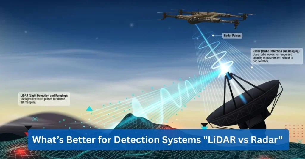
LiDAR uses laser pulses to measure distances precisely. Radar uses radio waves from a radar sensor, making it possible to detect objects, speed, and position even in places with poor visibility. This very difference shows an explanation of the common comparison of LiDAR vs. radar and radar vs. LiDAR. LiDAR and radar’s difference is all about accuracy and durability. What LiDAR produces is highly detailed 3D data that’s ideal for operations like surveying, mapping, and drone navigation that’s precise. On the other hand, radar performs better in rain, fog, and dust. When compared with sonar, radar vs. lidar vs. sonar: LiDAR uses light, radar uses radio waves, and sonar, which is sometimes confused with ultrasonic radar, uses sound, mainly in underwater applications.
This blog provides comprehensive information regarding the key differences of LiDAR and Radar, including their meaning, functions, and benefits.
What Does LiDAR Stand For, and How Is It Used?
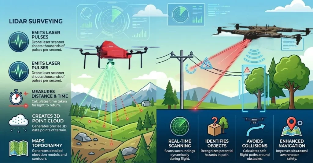
LiDAR stands for Light Detection and Ranging. The true meaning of LiDAR’s existence is the usage of laser light to measure distance. LiDAR creates accurate data of the shape of an object along with its height and position. This can be done through sending out laser pulses and measuring, specifically their return duration. This technology is entirely used in mapping, inspections, and LiDAR applications in drones nowadays.
Light detection and ranging is a measuring method that uses laser light instead of cameras or radar. A LiDAR sensor uses light transmission to measure distances by analyzing the reflected light from objects. The system demonstrates its power by producing precise environmental maps that enable researchers to study physical spaces.
How LiDAR Technology Works Using Laser Pulses
To keep LiDAR technology explained simply, LiDAR sensors use laser pulses, which they direct to the ground and surrounding objects. The system detects each pulse, which bounces back to the sensor after the pulse is emitted. The drone flight path enables the creation of accurate 3D data by combining these measurements.
Common Uses of LiDAR Sensors across Industries
There are many practical LiDAR sensor uses:
- Mapping with a clear and more accurate detail of a land and a terrain
- Planning as well as monitoring construction sites and infrastructure
- Helpful in analyzing crops, forests, and vegetation health
- Safely inspecting power lines and pipelines from the air
- Supporting navigation and collision avoidance for autonomous systems
Advantages of LiDAR for 3D Mapping and Object Detection
LiDAR technology can deliver detailed 3D mapping data when properly calibrated and used in suitable conditions because it measures depth and gathers detailed spatial information in both crowded and dimly lit environments. The method has improved object detection because it provides more accurate results which benefit drones that fly close to buildings, terrain, and equipment.
How ZenaDrone Uses LiDAR for Surveying and Obstacle Detection
LiDAR applications in drones are crucial, and ZenaDrone understands this fact. ZenaDrone uses LiDAR technology to help provide accurate results in surveying as well as to enhance the safety of the flight operations that are autonomous.
ZenaDrone develops LiDAR systems designed for detailed surveying and inspection tasks for drones, which produce precise 3D surveying maps and inspection results. Moreover, LiDAR sensors enable real-time detection of obstacles to protect autonomous drones from collisions in operational settings that are difficult to navigate in.
What Does Radar Stand For and How Is It Used?
Radar stands for Radio Detection and Ranging, and this one is part of those technologies that are deemed as behind-the-scenes, since it quietly keeps people, vehicles, and even drones safe.
In order for the radar technology to be explained in simple terms, it really comes down to one idea only, and that is radar uses radio waves to detect objects, measure how far away they are as well as to track how they move even if the visibility is poor.
From predicting storms through weather radar to modern cars through automotive radar uses, and of course radar for drones like those that are used by ZenaDrone, radar plays a major role in today’s smart systems.
Definition and Meaning of Radio Detection and Ranging
Radio Detection and Ranging is exactly what radar does, it detects objects and ranges (measures distance) using radio waves. A radar sensor produces or sends out signals that bounce off objects and return to the system. If these returning signals are analyzed, radar can determine the object’s distance as well as its direction and speed. This core concept is the reason why radar sensor applications are widely used and trusted in industries where reliability is essential.
How Radar Systems Work Using Radio Waves
To put radar technology explained in everyday language, radar functions through a process that resembles shouting into a canyon while listening for the returning sound. A radar system sends out radio waves, which bounce back to the system when the waves strike an object, including vehicles, aircraft, and terrain.
The radar sensor measures:
- Distance such as how long the signal takes to return
- Speed such as the changes in the signal frequency
- Location such as the signal direction
Different Types of Radar Systems
Many of the radar sensor applications are built for a specific kind of environment and tasks like:
- Weather Radar that is used in tracking storms, rainfall, and severe weather patterns
- Automotive Radar that is used for adaptive cruise control, avoidance of collision, and detection of blind-spot
- Aviation Radar that helps air traffic control monitor aircraft movement
- Defense Radar that detects aircraft. Missiles, and threats in maritime
- Radar for drones that supports detection and navigation of an obstacle, especially in places with low-visibility conditions
It is important to remember that each type uses the same core radio detection and ranging principle, but is fine-tuned for its specific purpose.
Advantages and Limitations of Radar Technology
ADVANTAGES | LIMITATIONS |
Radar technology works in darkness, fog, rain, and dust | Radar technology has lower image detail compared to LiDAR or cameras |
Radar technology can accurately detect speed and movement | Radar technology can have a struggle in distinguishing closely spaced objects |
Radar technology is reliable in long distances | Large systems may require more power |
This balance is why radar is often paired with other sensors rather than used alone.
Use of Radar in Vehicles, Aviation, and Defense Systems
The use of automotive radar is now common in everyday vehicles allowing safer driving through the use of features like emergency braking and lane monitoring. In the field of aviation, radar ensures safe aircraft separation and navigation. Defense systems, on the other hand, rely on radar for the use of threat detection and tracking early.
Radar for drones is gaining importance. Radar-based sensing for the purpose of improving autonomous safety flight has been explored by companies just like ZenaDrone, particularly in places where there’s limited visibility or difficult to detect obstacles with cameras alone.
What Are the Main Differences Between LiDAR and Radar?
Both technologies are important when discussing LiDAR vs. Radar comparison. They are crucial since they’re designed to detect objects and measure distance despite the fact that they work in different ways. A LiDAR sensor uses laser pulses, while radio waves are used by radar sensors.
Deeming this fundamental difference, their performance along with accuracy, range, and cost vary significantly. Below is a breakdown of the essential distinctions in LiDAR and Radar performance and applications in the real-world.
Differences in Accuracy and Measurement Resolution
The main distinction between LiDAR and radar systems comparison exists in their accuracy measurement capacities. A LiDAR sensor delivers extremely high-resolution 3D maps. The system shows object detection capabilities for small objects and sharp edges and fine structural details. This makes lidar radar accuracy noticeably higher when precise mapping and surveying are required.
The distance measurements from radar systems maintain consistent accuracy yet produce lower detail resolution results. A radar sensor can detect objects and measure speed accurately but it does not create highly detailed 3D images like LiDAR does.
In short:
- LiDAR: Higher measurement accuracy and sharper resolution
- Radar: Strong detection, but less detailed mapping
Sensor Range and Long-Distance Detection Capabilities
Sensor range comparison requires evaluation of how far each system detects objects. Radar achieves better performance because it can detect objects at greater distances. The longer detection range of radar systems results from their ability to use radio waves, which can travel longer distances and penetrate through obstacles such as rain and fog. LiDAR operates at shorter distances because it generates accurate data, which it transmits within that distance. Systems that require both long-distance operation and high detailed output should use combined systems.
So in terms of lidar radar performance, radar exceeds in long-distance detection, while LiDAR excels in detailed short-to-mid range mapping.
Speed Measurement and Object Tracking Performance
Radar possesses an inherent advantage for tracking moving objects through its capabilities. Radar sensors use the Doppler effect to measure speed directly and very accurately. That’s why radar is widely used in vehicles for adaptive cruise control and collision avoidance. LiDAR tracking is responsible for motion detection, but its main strength is all about spatial accuracy, which surpasses its ability to measure speed directly.
In practical lidar vs radar comparison, radar is stronger for speed measurement, while LiDAR is stronger for spatial and structural analysis.
Environmental Adaptability and Operational Reliability
Weather conditions affect the performance of LiDAR systems. Due to environmental challenges like rain, fog, dust, and smoke, LiDAR may deem these as obstacles affecting its performance. On the other hand, radar generally performs more consistently in harsh weather conditions. This is possible because radio waves can transmit through them with much greater efficiency. Because of this reason, Radar is often regarded as more reliable in low-visibility or complex environments.
Cost, System Complexity, and Deployment Considerations
Another important factor is the LiDAR radar cost difference. The costs of LiDAR systems exceed those of other systems because they need advanced laser components and they require high-resolution processing capabilities. The systems require additional resources due to advanced calibration methods and complex integration procedures.
Radar systems are typically much more affordable, easier to deploy, and easier to maintain.
However, they may not deliver the same level of mapping detail as LiDAR. The decision to use either lidar or radar depends on what level of precision customers require and how much they can afford to spend.
How ZenaDrone Uses Both Sensors for Optimal Navigation
ZenaDrone has demonstrated that LiDAR and radar should not be treated as opposing technologies which require separate treatments.
Strong navigation performance can be achieved using LiDAR sensors, particularly in detailed mapping scenarios. This can create detailed three-dimensional maps of the environment and its physical features. A radar sensor enhances obstacle detection and improves safety in low-visibility conditions.
Combining both systems can improve overall measurement accuracy and enhance detection coverage testing results while improving lidar radar capabilities in actual environmental conditions.
Using both technologies can support safer drone operations, with, of course, accuracy and reliability across different operational scenarios.
What Types of LiDAR and Radar Sensors Exist?
The different types of LiDAR sensors together with the different types of radar sensors explain their common use in drones and vehicles and advanced surveying systems. The system operates by using LiDAR laser pulses to determine distances whereas radar utilizes radio waves for distance measurement.
Each system has different sensor types which serve specific operational environments and specialized mission requirements.
The major radar system types together with the LiDAR classifications used in modern mapping and autonomous navigation systems, exist in the following detailed description:
LiDAR Sensor Types
Airborne LiDAR (Topographic and Bathymetric)
Airborne LiDAR systems use aircraft and drone technology to conduct aerial scanning of large areas of land. The systems find frequent application in surveying work and infrastructure development and environmental research activities.
- Topographic LiDAR technology identifies land height measurements together with all natural and manmade surface elements including roads and buildings and vegetation.
- Bathymetric LiDAR utilizes its special green laser wavelengths which can penetrate water to measure underwater terrain thus enabling its application in coastal mapping and riverbed analysis.
Airborne LiDAR technology provides drones with the capability to perform rapid high-resolution three-dimensional mapping across extensive land areas. ZenaDrone and other companies use airborne LiDAR technology to create precise digital elevation models through their drone-based systems.
Terrestrial LiDAR (Static and Mobile)
Terrestrial LiDAR systems can be operated from ground level and are often used for detailed structural and infrastructure mapping.
- A static terrestrial LiDAR system operates from a tripod base to conduct precise measurements of predetermined points. Its primary use case involves mapping construction sites and building structures and conducting forensic investigations.
- The mobile terrestrial LiDAR system operates from vehicles to gather data while traveling, which makes it suitable for road mapping and urban planning and corridor surveys.
It is very effective to use Terrestrial LiDAR when fine detail as well as millimeter-level precision are required.
Radar Sensor Types
There are multiple types of radar systems that are each designed for specific detection and measurement purposes. Below are the types of radar sensors that are commonly used in vehicles, defense applications, and of course, used in drones:
Doppler Radar
This type of LiDAR works by detecting small changes in the frequency of radio waves reflected from a moving object, enabling it to accurately calculate the object’s speed. Also, this radar sensor is used to track storms for weather monitoring, measure vehicle speed for traffic enforcement, and assist autonomous vehicles in detecting and responding to moving objects around them in real time.
Continuous-Wave Radar
Continuous-wave radar operates by sending out a steady radio signal which measures changes in frequency when the signal returns to the system. The system serves three primary functions which include:
- Speed detection
- Proximity sensing
- Short-range automotive radar systems
The system uses radar technology which operates with high efficiency and requires minimal space to work as a collision avoidance system.
Monopulse Radar
Monopulse radar determines object location through its capability to track targets with a single pulse transmission. The system achieves high directional precision which makes it suitable for use in:
- Tracking systems
- Defense applications
- Precision targeting systems
The system achieves its best performance through precise measurement of angles.
Synthetic Aperture Radar (SAR)
Synthetic Aperture Radar (SAR) is one of the most advanced radar system types. It uses motion to simulate a large antenna aperture, producing high-resolution images of terrain.
SAR can operate in:
- Low-visibility condition
- Nighttime environments
- Through cloud cover
SAR operates independently of lighting conditions, whereas optical systems depend on such conditions, which makes SAR systems more suitable for surveillance and mapping as well as disaster assessment purposes.
Ground-Penetrating Radar (GPR)
Ground-Penetrating Radar (GPR) sends radar pulses into the ground to detect buried objects or underground structures.
It is used for:
- Utility detection
- Archaeology
- Infrastructure inspection
- Subsurface mapping
GPR is valuable when surface-level scanning is not enough.
Applications for Each Sensor Type in Drones and Vehicles
Different sensor types are selected based on environmental needs and mission objectives:
- Airborne LiDAR is used in topographic mapping that is large-scale, flood modeling, and analyzing forestry.
- Terrestrial LiDAR is used in the documentation of construction, road surveys, and modeling structures.
- Doppler Radar is used for detecting speed and motion in autonomous systems
- Continuous-wave Radar is used for detecting short-range obstacles
- SAR is used in all-weather terrain imaging
- GPR is used in mapping underground and utility detection
ZenaDrone Sensor Configurations
ZenaDrone chooses the right mix of LiDAR and radar depending on the mission. Airborne LiDAR handles precise 3D mapping, while radar adds an extra layer of safety by improving obstacle detection and navigation.
Together, these sensors can enhance situational awareness and support safer, more accurate mapping and inspection workflows.
Advantages of Sensor-Specific Applications
It is important for organizations to understand the types of LiDAR sensors, types of radar sensors, and broader radar system types, because it will allow them to choose the technology for their operations. In many modern systems, especially drone platforms like ZenaDrone. In many cases, integrating both technologies provides a more balanced solution rather than relying on just one.
TYPE OF LiDAR/RADAR System | ADVANTAGES |
LiDAR Systems |
They provide a very detailed 3D spatial data |
Radar Systems |
These systems are reliable to perform in poor visibility conditions |
Airborne LiDAR |
It covers vast areas quickly |
Terrestrial LiDAR |
It delivers a very detailed localized scanning |
SAR and GPR |
These both expand the capabilities in detection that’s beyond the mapping in surface-level only |
Can LiDAR and Radar Work Together?
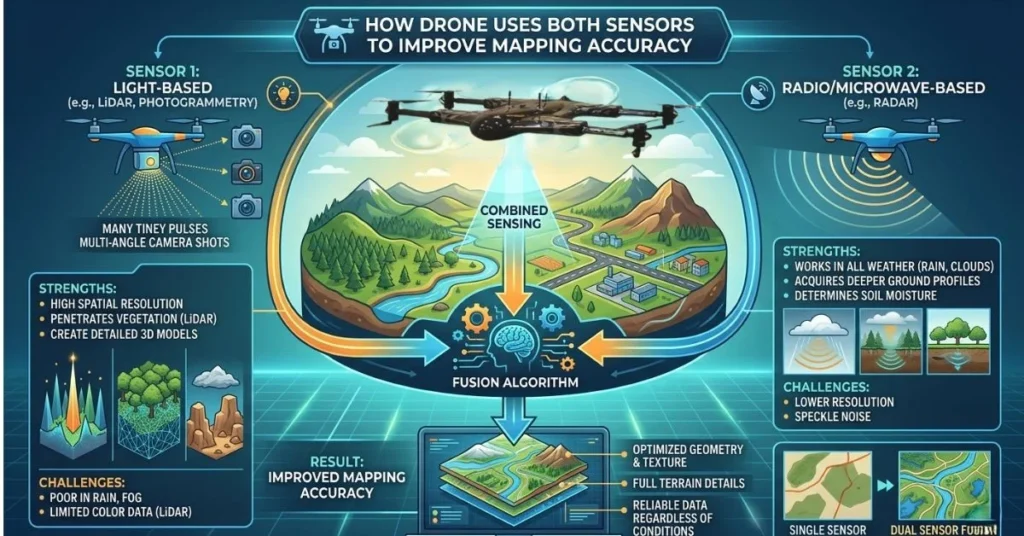
The combination of LiDAR and radar systems produces results that exceed the performance of either system alone. Modern systems implement lidar radar fusion as a dual sensor technology because it enables them to use both sensor capabilities. The method provides two main benefits: it improves object recognition and navigation while increasing system reliability in autonomous drones and vehicles.
Explanation of Sensor Fusion and Why It Matters
Sensor fusion combines data from multiple sensors to produce comprehensive and accurate environmental assessments. The integration of LiDAR and radar data requires the combination of LiDAR’s accurate three-dimensional spatial information with radar’s ability to track speed and movement.
Proper sensor integration enables systems to verify their data in real time through cross-checking. The two sensors work together to provide a complete solution when one fails due to weather or lighting conditions. The system achieves actual sensor synergy because its combined sensors produce more dependable outcomes than each sensor operates independently.
Benefits for Autonomous Vehicles and Drones
The use of lidar radar fusion systems provides three primary advantages for autonomous vehicle operations and autonomous drone sensor operations. The system provides three main advantages which include:
- More accurate detection of objects
- Improved distance and speed measurement
- Lessened false readings
- Stronger collision avoidance
- Better decision-making in real time
LiDAR provides superior 3D mapping capabilities while radar maintains reliable performance during rain and fog and dust. The two sensors deliver accurate results because of their combined ability to withstand various environmental conditions.
How ZenaDrone Uses Both Sensors to Improve Mapping Accuracy
ZenaDrone uses sensor integration methods to improve both operational flight safety and mapping accuracy. LiDAR systems create extremely detailed three-dimensional terrain models which radar technology improves through its capacity to detect obstacles and track movements.
ZenaDrone enhances mapping precision through sensor integration while maintaining stable autonomous navigation and secure operation in complex operational environments. The lidar radar fusion system enables the drone to perceive its surroundings better while making smarter operational decisions.
Real World Examples of LiDAR and Radar Hybrid Systems
There are so many real-world examples of LiDAR and Radar Hybrid Systems just like:
- Self-driving vehicles rely on LiDAR for shape recognition and radar for motion tracking.
- Drones for surveillance that combine radar imaging with 3D mapping
- Industrial inspections that need drones in order to get accurate terrain modeling and reliable obstacle detection
Advantages in Harsh Environmental Conditions
LiDAR struggles in heavy rain or fog, but radar keeps working even at night or in low light. That is why lidar radar fusion shines, staying reliable no matter the weather or visibility.
The combination of these autonomous drone sensors enables them to achieve precise object detection and stable navigation, along with reliable data collection, even under challenging weather conditions and restricted visibility. Modern autonomous systems operate with LiDAR and radar systems which function as complementary technologies instead of competing systems.
Smart sensor integration enables these technologies to work together for the development of safer and smarter drones and vehicles which possess expanded operational capabilities.
Which Technology Is Better: LiDAR, Radar, or Both?
When you are going to choose between LiDAR and Radar, or whether to use both, the right choice really depends on what the mission is, also consider the environment and performance needs as well.
It requires weighing factors to determine the best choice between lidar and radar. One must consider the factors first, just like cost, accuracy, and adaptability.
The sensor selection for drones and autonomous vehicle sensor comparison help determine which system or combination of systems deliver the best results.
Key Decision Factors Including Cost, Accuracy, and Environmental Adaptability
Choosing a sensor starts with three key factors:
Accuracy: LiDAR sensors are excellent in high-resolution 3D mapping and radar sensors are reliable in detecting objects at long range as well as in poor visibility.
Environmental Adaptability: Radar performs excellently when there’s rain, fog, or even low light, whereas LiDAR works best in clear conditions.
Cost and Efficiency: It is important to consider lidar radar cost-benefit and lidar radar efficiency because it balances performance in contrast with budget and operational needs
Situations Where LiDAR Is the Preferred Choice
LiDAR is preferred when the operations are:
- Mapping and Surveying have to be high-resolution
- Structural inspections
- Autonomous navigation that needs 3D detailed modeling
Situations Where Radar Is the Preferred Choice
Radar is preferred when:
- There’s heavy rain, fog, or dust
- It’s nighttime and low-light
- There is a need for long-range motion detection and collision avoidance
Benefits of Combining Both Technologies in Drones
When both LiDAR and radar are used, it creates a hybrid system that maximizes strengths and minimizes weaknesses. Lidar radar fusion offers:
- High accuracy in 3D mapping and robust detection of an obstacle
- Autonomous navigation that’s stable in all conditions
- Operational safety and improved data reliability
ZenaDrone as a Case Study for Hybrid Sensor Use
ZenaDrone uses LiDAR and radar systems according to its operational needs. Airborne LiDAR delivers precise 3D maps for surveying, while radar enhances obstacle detection and flight safety. The hybrid system shows how effective performance can be achieved through intelligent sensor selection for drones and autonomous vehicle sensor comparison. This approach demonstrates how hybrid sensor systems can support safe and adaptable autonomous operations.
How Do Radar and LiDAR Compare With Other Sensors?
The comparison between LiDAR and radar technologies and other sensor types requires a proper understanding to enable efficient comparison between drone sensor technologies and autonomous vehicle sensor systems. The high-precision 3D mapping capabilities of LiDAR exist alongside the distinct operational advantages that cameras and ultrasonic sensors and sonar systems provide different applications.
LiDAR vs Cameras: 3D Mapping vs 2D Imaging
Lidar vs. camera sensors show their primary distinction through their ability to measure depth. Cameras create high-resolution two-dimensional images which show colors but lack the ability to measure distances and create three-dimensional maps. The LiDAR sensors provide exact three-dimensional spatial information which allows for precise terrain mapping and obstacle detection in both dimly lit spaces and intricate environments.
LiDAR vs Ultrasonic Sensors: Range and Precision Differences
Comparing lidar vs ultrasonic sensors, LiDAR provides extended distance detection capabilities which operate with greater accuracy than ultrasonic sensors. The system enables precise outdoor mapping and navigation through its ability to detect distant objects. Ultrasonic sensors excel at short-range obstacle detection and are often used for proximity alerts in drones and vehicles. The choice depends on whether accuracy or simplicity is more important for a given task.
LiDAR vs Sonar: Underwater vs Aerial Detection
In lidar vs sonar comparisons, sonar is designed for underwater sensing, detecting objects beneath the surface using sound waves. LiDAR creates 3D maps of terrestrial and aerial spaces but cannot measure underwater areas. Each sensor performs best in its designated environment, with sonar specifically designed for underwater operations and LiDAR designated for aerial and terrestrial environments.
When Each Sensor Is Optimal for Drones or Vehicles
Different missions call for different sensors:
- LiDAR and Radar: 3D mapping with high-precision and detection of an obstacle in any conditions, may it be weather or light condition
- Cameras: Visual recognition, classification of object, and information of color
- Ultrasonic Sensors: Avoidance of short-range collision
- Sonar Systems: Navigating and mapping underwater
ZenaDrone Sensor Integration Strategy
ZenaDrone uses LiDAR and radar and cameras and ultrasonic sensors to match its mission needs. ZenaDrone combines these technologies to create obstacle detection systems and 3D mapping systems and navigation systems. The smart sensor system delivers optimal performance across various environments, demonstrating the effectiveness of drone sensor technologies and the practicality of autonomous vehicle sensor comparisons.
FAQ About LiDAR vs Radar
Are LiDAR and Radar similar?
Not exactly. LiDAR uses lasers for precise distance measurements, while radar uses radio waves. Both spot objects, but each works best in different conditions.
Difference between LiDAR and a laser scanner?
A laser scanner is simpler, capturing surfaces in 2D or basic 3D. LiDAR is more advanced, quickly creating detailed and accurate 3D maps.
Is LiDAR the same as infrared?
No. LiDAR uses laser light, typically in near-infrared wavelengths, to measure distances. Infrared detects heat, so it’s more for sensing temperature than mapping physical shapes.
Difference between 2D, 3D, and 4D LiDAR?
- 2D LiDAR scans in a flat plane.
- 3D LiDAR captures depth and creates full three-dimensional maps.
- 4D LiDAR adds time or motion tracking, so it can detect moving objects and measure their speed.
Do drones like ZenaDrone use both sensors?
Yes. ZenaDrone combines LiDAR and radar to get precise 3D mapping and reliable obstacle detection, even in challenging weather or low-light conditions.
Can Radar work in rain?
Yes. Radar uses radio waves, so it performs well in rain, fog, dust, and even at night, making it highly reliable for all-weather operations.
Contact Us
Thank you for your message. It has been sent.