


Public Safety Drones Enhancing Emergency Response and Safety Operations
When emergencies strike, every decision counts. Public safety agencies must act quickly and make informed decisions to protect responders and communities during incidents such as wildfires, search and rescue operations, public events, and storm damage assessments.
Traditionally, agencies have relied on ground personnel, patrol vehicles, and manned aircraft to gather information during critical incidents. While these methods remain valuable, advances in drone technology have introduced new ways to improve situational awareness, accelerate decision-making, and support safer operations.
Today, public safety drones are becoming an increasingly important tool for law enforcement agencies, fire departments, emergency management teams, search and rescue units, and critical infrastructure operators. Equipped with advanced imaging systems, real-time communications, and intelligent software, these aerial platforms help responders gain visibility into evolving situations without placing personnel directly in harm’s way.
This guide explores how public safety drones are used, what capabilities matter most, how agencies can build successful drone programs, and how emerging technologies such as artificial intelligence and automation are shaping the future of emergency response.
What Are Public Safety Drones?
Public safety drones are unmanned aerial systems (UAS) designed to support emergency response, law enforcement, disaster management, and other mission-critical operations.
Unlike recreational drones, public safety platforms are typically integrated into operational workflows and deployed to gather aerial intelligence, improve situational awareness, and support decision-making during dynamic events.
These systems may carry a variety of sensors and payloads, including:
- High-resolution visual cameras
- Thermal imaging sensors
- Low-light cameras
- Mapping and surveying equipment
- Environmental monitoring sensors
- Communication and relay equipment
The primary goal is not simply to capture aerial footage. Instead, public safety drones help agencies understand what is happening, where resources should be deployed, and how risks can be reduced during an incident.
Why Public Safety Agencies Are Increasingly Using Drones
Public safety environments are often unpredictable. Responders may face limited visibility, hazardous conditions, large operational areas, and rapidly changing circumstances.
Drones help address these challenges by providing immediate aerial visibility and operational flexibility.
Some of the most common benefits include:
- Faster Situational Awareness: Rather than waiting for personnel to physically access an area, operators can launch a drone and quickly obtain an aerial overview of conditions.
- Improved Responder Safety: Hazardous environments such as active fires, unstable structures, flood zones, or chemical incidents can often be assessed remotely before personnel enter the area.
- Better Resource Allocation: Command teams can make more informed decisions when real-time information is available, helping agencies deploy personnel and equipment where they are needed most.
- Enhanced Operational Efficiency: Drones can assist with monitoring, mapping, inspections, and surveillance tasks that might otherwise require significant manpower and resources.
- Expanded Visibility: Aerial perspectives often reveal information that cannot be observed from the ground, particularly in large-scale incidents or difficult terrain.
Key Applications of Public Safety Drones
Search and Rescue Operations
Search and rescue missions are among the most impactful applications for drone technology. Locating a missing person can be challenging when responders are working in forests, mountainous terrain, flood zones, and low-visibility conditions. Drones equipped with thermal imaging and live video capabilities can help search teams cover larger areas more efficiently while maintaining communication with command personnel.
In many situations, aerial observations help responders prioritize search zones and coordinate rescue efforts more effectively. As autonomous flight technologies continue to evolve, agencies are also exploring ways to automate portions of search operations while maintaining appropriate human oversight.
Law Enforcement Applications
Law enforcement agencies use drones for a wide range of operational needs.
Common applications include:
- Crime scene documentation
- Tactical overwatch
- Traffic incident assessment
- Missing person investigations
- Public event monitoring
- Perimeter security
High-resolution aerial imagery can support investigations, while live video streams provide commanders with a broader operational picture during active incidents. Many agencies also integrate drone data into evidence management workflows, helping preserve visual records for investigative and reporting purposes.
Firefighting and Wildfire Response
Fire incidents often create conditions that limit visibility and increase risk for personnel. Thermal imaging systems allow operators to identify heat signatures, monitor fire behavior, and observe areas that may not be visible from the ground.
Fire departments may use drones to:
- Monitor wildfire progression
- Identify hotspots
- Assess structural damage
- Support evacuation planning
- Improve firefighter safety
By providing continuous aerial intelligence, drones help incident commanders make more informed decisions during rapidly evolving situations.
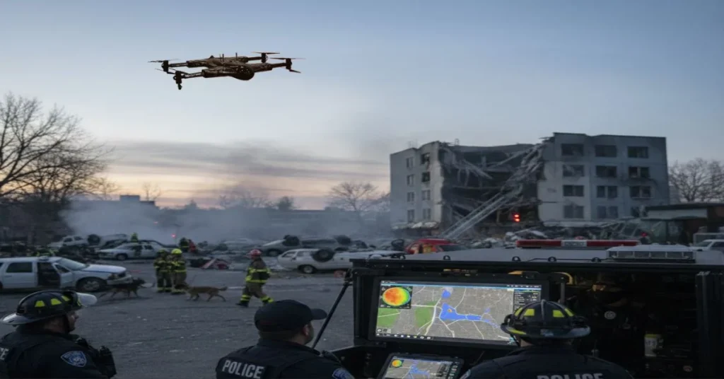
Disaster Response and Damage Assessment
Natural disasters frequently create widespread damage across large geographic areas. After severe weather events, floods, earthquakes, or other emergencies, agencies often need to assess conditions quickly while managing limited resources.
Drones can assist by:
- Mapping affected areas
- Identifying access routes
- Documenting infrastructure damage
- Supporting emergency planning
- Coordinating multi-agency response efforts
The ability to collect aerial intelligence shortly after an event can improve operational awareness and accelerate recovery planning.
Emergency Medical Support
Emergency medical teams increasingly recognize the value of aerial intelligence during medical incidents and disaster response scenarios.
Drones can assist by:
- Assessing accident scenes
- Evaluating access routes
- Supporting triage planning
- Providing live situational updates
As technology evolves, agencies continue exploring additional ways drones may complement emergency medical workflows while supporting faster and safer response operations.
Critical Infrastructure Assessment
Public safety responsibilities often extend beyond emergency response. Agencies may be responsible for monitoring bridges, roads, utilities, public facilities, transportation corridors, and other critical assets.
Drone inspections allow teams to evaluate infrastructure conditions while reducing the need for personnel to access hazardous or difficult-to-reach locations. These assessments can support preventative maintenance, risk management, and emergency preparedness initiatives.
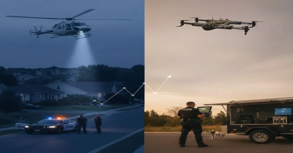
Public Safety Drones vs Traditional Response Methods
Drones are not intended to replace every traditional response method. Instead, they provide additional capabilities that complement existing operations. Compared with ground-based assessments, drones can often provide broader visibility in less time.
Compared with manned aircraft, drones generally require fewer personnel and can be deployed quickly for many operational scenarios. Most importantly, drones help agencies collect actionable information before responders are exposed to potentially dangerous environments.
The goal is not replacing people it is helping people make better decisions with better information.
Features That Matter Most
When evaluating public safety drone solutions, agencies should focus on mission requirements rather than individual specifications alone.
Key capabilities may include:
- Thermal Imaging: Useful for locating heat signatures, monitoring fire activity, and supporting search operations.
- Real-Time Video Streaming: Allows decision-makers to receive live situational intelligence during active incidents.
- AI-Assisted Analytics: Emerging systems can assist with identifying objects, tracking movement patterns, and highlighting areas requiring attention.
- Autonomous Flight Planning: Automation can help standardize repetitive missions while reducing pilot workload.
- Weather Resistance: Public safety operations often occur in less-than-ideal environmental conditions.
- Secure Communications: Protecting operational data remains an important consideration for agencies handling sensitive information.
- Payload Flexibility: Different missions may require different sensor configurations, making modular systems particularly valuable.
How to Build a Successful Public Safety Drone Program
Technology alone does not guarantee success.
Agencies should consider a structured implementation approach that includes:
- Defining Mission Objectives: Identify operational challenges and determine how drones may support those needs.
- Training and Operational Readiness: Personnel should receive appropriate training for mission requirements and organizational procedures.
- Standard Operating Procedures: Clear policies help establish consistency, accountability, and safe operational practices.
- Fleet Management: Organizations should plan for maintenance schedules, battery management, software updates, and equipment lifecycle considerations.
- Data Management: Collected imagery and operational data should be stored, managed, and accessed according to organizational policies.
- Budget Planning: Decision-makers should evaluate both initial acquisition costs and long-term operational expenses.
Important Operational and Compliance Considerations
Regulatory requirements vary depending on location, mission type, and operational environment. Organizations should verify applicable requirements and consult relevant authorities before conducting drone operations.
Key considerations may include:
- Airspace restrictions
- Night operations
- Privacy considerations
- Data protection practices
- Operational approvals
- Evidence management procedures
Maintaining public trust often depends on transparency, responsible drone usage, and clear accountability measures.
Emerging Trends in Public Safety Drone Technology
Public safety drone programs continue to evolve beyond simple aerial observation.
Several emerging trends are influencing future operations:
- Drone docking systems
- Remote operations centers
- Expanded automation
- Advanced sensor integration
- Connected public safety ecosystems
- Real-time data sharing platforms
- Enhanced interoperability between agencies
These developments aim to improve response capabilities while reducing operational complexity.
How AI and Automation Are Changing Emergency Response
Artificial intelligence is increasingly becoming part of modern public safety workflows.
While human decision-making remains essential, AI-powered tools can assist with:
- Object detection
- Pattern recognition
- Incident monitoring
- Route optimization
- Data analysis
- Situational intelligence
Similarly, autonomous flight systems may help agencies conduct routine monitoring missions, infrastructure inspections, and time-sensitive deployments more efficiently. As these technologies mature, agencies will continue evaluating how automation can support operational effectiveness while maintaining appropriate oversight.
Case Study: How a Public Safety Drone Enabled a Rapid Search and Rescue Operation
In the event of natural disasters, accidents, or emergencies, individuals may be missing, and a call to emergency services must be made. Search and rescue (SAR) operations, specifically, are organized efforts to locate and aid missing persons in difficult terrain and low-visibility conditions.
Though most methods and technologies can be used in SAR operations, there are still issues that need to be addressed, such as limited ground visibility, time-sensitive rescue conditions, and safety risks to first responders. All challenges can be overcome with modern drone solutions that are equipped with thermal imaging and real-time video transmission. Public safety drones enable coverage of a large search area instantly, while also showcasing live video to detect any heat signatures and even assess the individual’s condition remotely. Having this practical use of drones in public safety emphasizes how advanced UAV technology is prepared to improve SAR operations and emergency response.
Drones for public safety also impact instant safety in terms of aerial situation awareness and faster target detection. Moreover, coordinators and operators can easily guide rescue teams by using precise Global Positioning System (GPS) coordinates that lead them to reach the victim safely and efficiently. This results in a successful rescue, along with a reduced search time and improved responder safety.
According to ZenaDrone on X, “Every Second Counts in an Emergency! Drones swiftly navigate hard-to-reach areas, providing critical insights while keeping responders out of harm’s way—a true game-changer for disaster response.”
Ultimately, public safety drones have been constantly attesting as to how technological developments are not only support tools, but also enhance workflows when it comes to response speed and safety in SAR operations. Public safety drones are utilized for each and every operation for their advantages to speed, safety, and life-saving outcomes.
Choosing the Right Public Safety Drone Solution
Every agency has unique operational requirements.
Before selecting a drone platform, decision-makers should evaluate:
- Mission objectives
- Geographic environment
- Sensor requirements
- Training resources
- Budget constraints
- Data security requirements
- Scalability needs
- Maintenance expectations
Rather than focusing solely on specifications, agencies should consider how a drone solution fits within broader operational workflows and long-term program goals.
Final Thoughts
Public safety drones have evolved from specialized tools into valuable operational assets that support emergency response, law enforcement, disaster management, infrastructure assessment, and community safety initiatives.
Their true value lies not in the technology itself, but in how effectively they help responders gain situational awareness, reduce risk, improve coordination, and make informed decisions when every moment matters.
As drone technology continues to advance through AI-powered analytics, automation, improved sensors, and connected operational ecosystems, agencies will have even greater opportunities to enhance mission effectiveness while maintaining a strong focus on safety, accountability, and public trust. For organizations evaluating the future of public safety operations, drones are increasingly becoming an important part of the broader emergency response toolkit.
FAQs About Public Safety Drones
Can drones replace helicopters?
Drones and helicopters serve different purposes. Many agencies use drones to complement existing aviation assets by providing rapid aerial visibility and operational flexibility.
Do public safety drones record video?
Yes. Drones for public safety can record high-resolution video and thermal imaging.
Are thermal cameras important for public safety missions?
Thermal imaging can support a variety of missions, including search and rescue, firefighting, and situational awareness in low-visibility environments.
How do agencies manage drone data?
Data management approaches vary by organization and may include secure storage systems, evidence management workflows, and internal governance policies.
What training is required?
Training requirements depend on jurisdiction, mission type, and organizational policies. Agencies should verify applicable requirements and ensure personnel receive appropriate instruction.
What should agencies evaluate before purchasing a drone?
Mission requirements, operational objectives, sensor capabilities, scalability, support resources, data security, and total program costs are all important considerations.
Contact Us
Thank you for your message. It has been sent.