


Seismic Survey Explained Types, Process, Equipment & Uses
Earthquakes are recognized as seismic activity, and it’s essential to survey geological structures. Seismic surveying encompasses different types, with their own process, equipment, and numerous uses for dynamic cases. Modern industries like the mining industry often rely on seismic surveys and seismic data acquisition.
It’s imperative to understand more about seismic surveys as sectors increasingly utilize these geophysical methods for subsurface mapping. This blog will explain seismic survey and associated information, such as types, process, equipment, and cases.
What Is a Seismic Survey?
A seismic survey is a renowned geophysical method that is used by many service companies and government agencies in order to image and map the Earth’s subsurface. The purpose of seismic data acquisition and geophysical survey allows experts to visualize structural traps, faults, and mineralized zones. Seismic surveying involves generating controlled acoustic waves, and the reflections off various geological layers are recorded by seismologists and technicians.
Underground structures can be easily identified through seismic waves by analyzing wave patterns. After analyzing, the exact depth, thickness, and orientation of rock strata are then calculated. These analyses and calculations are processes that reveal geologic features that are important for subsurface mapping.
With that, seismic survey data and seismic data acquisition are regarded to be important for numerous industries like oil and gas, mining and mineral, geothermal energy, etc. These sectors and companies rely on seismic survey data for mitigating risk and optimizing resource recovery. Since seismic survey practically provides a reliable image and map of the Earth’s interior, a variety of industries, including the global energy and infrastructure sectors, have begun to rely on seismic survey data.
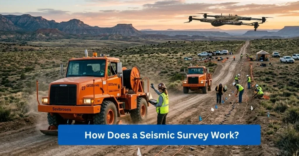
How Does a Seismic Survey Work?
Specialized experts conduct seismic surveys by generating seismic energy through imaging the controlled shock waves at the Earth’s surface. The intentional creation of controlled shock waves is critical for seismic data acquisition and further accurate subsurface mapping.
There are specialized sensors, such as geophones and hydrophones, that record wave movement in order to detect the vibrations and pressure changes from the subsurface. Geophones and hydrophones are utilized as well for converting mechanical energy into electrical signals that are to be digitized and stored by experts.
Data is converted into subsurface images through a complex computational process that involves algorithms and data processing, wherein bending and scattering of waves are corrected from repositioning reflected energy. Converting data into a cohesive visual model allows proper interpretation and can be a key factor in a successful geophysical survey.
How Reflection & Refraction Methods Differ?
When it comes to seismic survey, there are reflection seismology and refraction seismology that are different in terms of prioritizing the measurement of specific wave paths.
Reflection seismology:
A method that captures waves that bounce off deep interfaces, and this provides a high-resolution image of deep structures.
Refraction Seismology:
A method that focuses on waves that travel along the boundary between two layers and is necessary for measuring the velocity and depth of shallow rock.
Reflection seismology and refraction seismology are both appropriate methods for measuring seismic waves, which are showcased by the comparison table below:
Feature | Seismic Reflection | Seismic Refraction |
Physical Principle | Echo-location; waves “bounce” off boundaries (Acoustic Impedance). | Bending of waves along boundaries (Snell’s Law). |
Primary Target | Deep structures (faults, reservoirs, deep basins). | Shallow boundaries (bedrock, water table, soil layers). |
Depth Range | Superior for depths >100 feet up to several km. | Best for near-surface investigation (<100 feet). |
Resolution | High resolution: produces a true “image” of layers. | Lower resolution; produces a “layered velocity model.” |
Industry Usage | Oil & Gas, deep mining, carbon storage (CCS). | Engineering, construction, and environmental site surveys. |
Seismic wave travel time and amplitude?
Interpreting the composition of the Earth has two primary metrics, which are travel time and amplitude. While travel time refers to how long a seismic wave takes to return to the sensor, amplitude is the strength of the returning signal.
Travel time also indicates the depth of the layer and the speed/density of the material, and amplitude also implies a contrast between two rock types, suggesting a significant change in density or porosity.
What Technologies Are Used in Seismic Data Collection?
Collecting seismic data is a meticulous process that involves utilizing seismic survey technology. Experts are able to do so efficiently with the following:
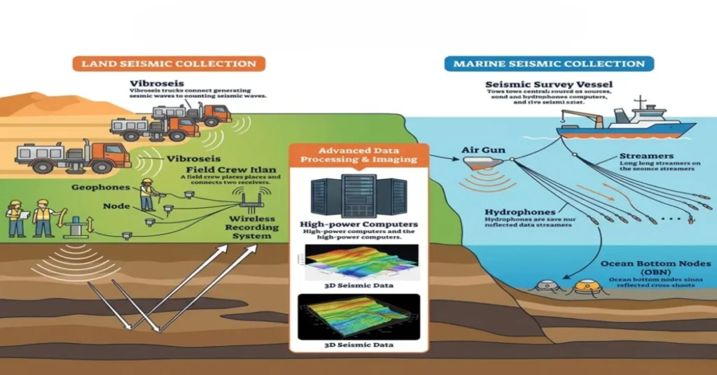
Land-based vs Marine Seismic instruments
There are distinct sensor technologies that capture the movement of seismic waves in different media, like land-based and marine seismic instruments.
Geophones are sensors that are often used on land to convert ground vibrations into electrical signals. There are also hydrophones, which are utilized in marine environments to map the seabed.
Feature | Land-Based Instruments | Marine Seismic Instruments |
Primary Sensor | Geophone: Measures particle velocity of the ground motion via a magnet and coil. | Hydrophone: Measures changes in water pressure using piezoelectric crystals. |
Deployment Method | Spiked into the soil or towed via a land-streamer for rapid coverage. | Towed in long cables called streamers or placed on the seabed as Ocean Bottom Nodes (OBN). |
Vibrator Trucks, Explosives, and Air Gun Sources
Geophysical surveys entail that targets have a specific terrain and depth that requires a specific technology.
Vibrator trucks:
Also known as vibroseis, are used on land with their heavy baseplates to send controlled, low-frequency “sweeps” of vibrations into the ground.
Explosives:
Commonly used in remote or rugged areas to provide a high-energy pulse
Air guns:
Are industry-standard, which release compressed air bubbles offshore to create pulses that travel through the water and into the seabed.
Feature | Vibrator Trucks | Explosives | Air Gun |
Primary Environment | Onshore: Flat terrain, deserts, and urban areas. | Onshore/Transition: Mountains, jungles, and swamps. | Offshore: Oceans, deep seas, and large lakes. |
Logistical Effort | Heavy vehicles require road access or flat ground. | Lightweight; can be carried by hand into remote regions. | Requires large vessels with powerful air compressors. |
Modern Nodal Seismic Systems
Lastly are the modern nodal seismic systems that are capable of replacing heavy cables with individual, autonomous recording nodes. Modern nodal seismic systems have each self-contained node with features of a battery, GPS, and internal storage. This specific technology allows high-density surveys that involve thousands of deployable sensors on foot or by drone.
What Are the Types of Seismic Surveys?
There are numerous types of seismic surveys, with 2D seismic surveying as a linear method that records the energy from a source moved along the same trajectory. 3D seismic involves high-resolution multi-directional wave reflections, whereas 4D seismic refers to a time-lapse of repeated 3D surveys for reservoir monitoring.
Feature | 2D Seismic | 3D Seismic | 4D Seismic |
Dimension | Linear/Profile: A single vertical cross-section. | Volumetric/Block: A continuous 3D data cube. | Time-lapse: A series of 3D cubes over time. |
Primary Purpose | Regional exploration and identifying large structures. | Detailed reservoir mapping and drilling site selection. | Monitoring fluid movement and pressure changes. |
Data Density | Low: Samples are gathered along isolated lines. | High: Full-azimuth coverage across a grid. | Very High: Multiple high-density 3D datasets. |
Differences in Accuracy, Cost, and Image Clarity
Knowing how the types of seismic surveys have their own specific method and purpose, it is expected that to also have differences in terms of accuracy, cost, and image clarity. Observe the table below that portrays differences between 2D seismic, 3D seismic, and 4D seismic:
Feature | 2D Seismic | 3D Seismic | 4D Seismic |
Accuracy | Lower: Provides a single vertical “slice.” Susceptible to “out-of-plane” reflections. | High: Full volumetric coverage ensures precise spatial positioning of structures. | Highest: Measures the change in accuracy over time (temporal precision). |
Cost | Economical: Lowest cost-per-mile; ideal for large-scale reconnaissance. | Moderate to High: Significant investment in sensor density and processing power. | Premium: Multiple high-resolution 3D surveys repeated over the years. |
Image Clarity | Basic: Visualized as a flat cross-section; lacks fine stratigraphic detail. | Detailed: Produces a clear 3D “cube” that can be sliced and rotated. | Dynamic: Visualizes the movement of fluids (gas/water) within the 3D cube. |
Onshore vs Offshore Survey Environments
In addition to the multi-dimensional seismic surveys, there are also the onshore and offshore survey methods. Onshore seismic surveys frequently take place on land, like the geophone, and involve complex topography, urban noise, and the “weathering zone” of topsoil. For offshore seismic surveys that occur in marine environments, such as the hydrophone, the seismic wave travels through the water.
Feature | Onshore (Land) Environment | Offshore (Marine) Environment |
Primary Sensor | Geophones: Spiked into the ground to measure mechanical vibrations. | Hydrophones: Towed in the water to detect acoustic pressure changes. |
Data Coupling | Variable: Highly dependent on soil type and contact with the ground. | Consistent: Water provides a uniform medium for wave transmission. |
Ambient Noise | “Cultural noise” from traffic, wind, and industrial activity. | “Environmental noise” from tides, currents, and marine life. |
Why Are Seismic Surveys Important?
After discovering more about seismic surveys and their technologies and types, it’s imperative to also understand seismic survey importance. Here are three reasons why seismic surveys are important:
Reduce Drilling Risks:
Conducting seismic surveys can reduce drilling risks since the acoustic data can identify any geohazards and optimize reservoir targets. With seismic survey analysis, issues like high-pressure gas pockets, unstable salt domes, or unexpected fault lines are detected and can ultimately lead to drilling risk reduction.
Understanding Geological Formations:
Seismic surveys also lead to understanding geological formations, and the insights can result in better resource exploration. By comprehending the geological formations and structures, experts can have a physical model of the Earth’s crust. It can preserve historical sites while also helping individuals gain a deeper understanding of the land’s history.
Predicting Geohazards and Faults:
There are structural weaknesses, such as geohazards and faults, that can be predicted through seismic surveys. Not only do seismic surveys map the Earth’s subsurface, but conducting such surveys can also benefit earthquake studies.
How Are Seismic Surveys Used in Oil & Gas Exploration?
Oil & gas exploration involves searching for such material underground and underwater, and seismic surveys in oil and gas are significantly necessary. Seismic surveys can be used in exploring oil and gas through the following:
Identifying Potential Hydrocarbon Pockets
Hydrocarbon pockets refer to amplitude anomalies, which imply the presence of oil or gas trapped within rock layers. Identifying potential hydrocarbon pockets can help describe the size, depth, and fluid content when exploring oil and gas. Reservoir characterization can also ensure that the environmental footprint is reduced.
Improving Drilling Accuracy with Seismic Imaging
Another contribution is how seismic surveys in oil and gas can improve drilling accuracy. Using high-resolution seismic methods can bring precision in narrow zones and around hazardous geological obstacles. Improving drilling accuracy and having easy navigation of the subsurface can help reduce operational costs.
Reservoir Lifecycle Monitoring
The reservoir lifecycle monitoring is usually conducted at a 4D time-lapse seismic survey, and this can efficiently track how materials move and pressures change. Seismic surveys in oil and gas can recognize certain oil and gas resources that were not captured properly and monitor the integrity of the reservoir’s seal.
How Are Seismic Surveys Used in Renewable Energy?
In addition, seismic surveys for renewable energy are also commonly conducted. Here’s how seismic surveys are used in renewable energy:
Mapping Geothermal Reservoirs
Geothermal exploration uses seismic waves in order to identify underground hotspots, fracture networks, and fluid-filled reservoirs that are sources for heat and electricity. Seismic surveys can help with mapping geothermal reservoirs by distinguishing between solid rock and permeable zones that contain hot water and/or steam.
Evaluating Seabed Stability for Wind Turbines
Offshore wind site assessment also utilizes seismic surveys, since it provides images of shallow layers of the seabed. Evaluating seabed stability for wind turbines can use seismic surveys for detecting hazards. This helps teams ensure that there is long-term structural integrity for the wind turbines and similar foundations.
Subsurface Risk Assessment for Green Projects
Lastly, a seismic survey for renewable energy also includes subsurface risk assessment for green projects. This analysis of geological stability, earthquake vulnerability, and geomechanical response is necessary for green infrastructure and operations. Assessing seismic waves can track changes in Earth’s crust, which is of interest in certain green projects.
What Are the Steps in Conducting a Seismic Survey?
Conducting a seismic survey requires meticulous work, as it involves a set of steps that should be taken solemnly. The seismic survey process is as follows:
Pre-survey Planning and Terrain Assessment:
Firstly, the pre-survey planning and terrain assessment involve a strategic design that determines the optimal survey geometry, sensor density, and energy source based on the project’s requirements. Geophysicists conduct this planning and assessment to ensure that the next step will proceed safely and efficiently.
Field Acquisition and Data Recording;
The second step is field acquisition and data recording, wherein the seismic survey is physically executed. Energy sources create acoustic waves, and sensitive records are engineered to capture the data.
Advanced Seismic Processing:
Following the second step is the advanced seismic process that computes and organizes the raw field data. Advanced seismic processing involves mathematical algorithms that transform raw recordings into a coherent image. This results in a prepared dataset for final data modeling and leads to a clear map of acoustic waves of the Earth’s subsurface.
Interpretation and Geological Modeling:
Lastly, specialized experts interpret and geologically model the processed images. Interpretation and geological modeling are the specific parts of the process that identify rock layers, faults, and fluid-filled reservoirs.
What Equipment Is Used in Seismic Surveys?
In most seismic surveys, certain seismic survey equipment is utilized. Here are the seismic survey equipment that are deployed in the field:
Seismic Receivers
Geophones, Micro-Electro-Mechanical Systems (MEMS) sensors, and nodes are a few of the many seismic receivers. These highly sensitive instruments are built to detect minute ground vibrations and/or pressure changes, which are then converted into recordable electrical signals.
Feature | Geophones | MEMS Sensors | Nodes |
Sensing Technology | Electromagnetic: Moving coil in a magnetic field. | Digital Accelerometer: Micro-machined silicon chip. | Integrated System: Combined sensor, GPS, and recorder. |
Best Use Case | Large-scale, budget-conscious onshore exploration. | Full-Waveform Inversion (FWI) and urban vibration monitoring. | Remote, rugged, or urban areas where cables are restricted. |
Seismic Sources
Other than seismic receivers, seismic sources that consist of vibroseis, explosives, and air guns are also used to generate controlled acoustic energy in seismic surveys. Seismic sources refer to tools that are utilized for a variety of environments, vibroseis for land-based surveys, explosives for small locations, and air guns for marine surveys.
Feature | Vibroseis | Explosives | Air Gun |
Primary Environment | Onshore: Flat terrain, deserts, and urban areas. | Onshore/Transition: Mountains, jungles, and swamps. | Offshore: Oceans, deep seas, and large lakes. |
Data Recording and Telemetry Systems
Seismic survey equipment also includes data recording and telemetry systems, which are central to a seismic survey. It’s capable of timing, digitizing, and transmitting the data collected. Data recording and telemetry systems can enable teams to begin seismic processing and significantly reduce the turnaround time for final project delivery.
How Much Does a Seismic Survey Cost, and What Affects Pricing?
Like any other technological process, seismic surveys have a cost. Understand more about seismic survey cost and what affects the pricing through the following:
Cost of Land Seismic Surveys vs Marine
As mentioned above, seismic surveys are conducted on either land or seabed, and that leads to different costs that are based on the particular environment they inhabit. Land seismic surveys have lower mobilization costs but higher per-unit expenses due to the intense labor. However, marine seismic surveys involve massive capital expenditures for covering larger areas faster.
Cost Factor | Land-Based | Marine |
Typical Daily Rate | $25,000 – $85,000 | $150,000 – $400,000+ |
Primary Cost Driver | Labor & Logistics: Hiring large crews to manually plant thousands of nodes. | Equipment & Fuel: Maintenance of vessels, air compressors, and streamers. |
Processing Costs | High: Correcting for complex near-surface soil variations (weathering layer). | Moderate: Uniform water velocity simplifies early processing stages. |
Crew Size, Equipment, and Logistics
Moreover, firms also need to consider the cost of the crew, equipment, and logistics. A standard survey crew refers to specialists and workers who need to be financially compensated, and the equipment cost also reflects the technology utilized during the project. Operational factors and logistics include the overall number of personnel, hardware, and the deployment itself.
Operational Factor | Land Survey | Marine Survey |
Typical Crew Size | 80 to 200+ personnel: Massive crews for node deployment/retrieval. | 40 to 70 personnel: Specialized maritime and geophysical crew. |
Primary Equipment | Up to 1,000,000 Nodes + 4-8 heavy Vibroseis trucks. | 12 to16 Streamers (each 8-12km) + Air Gun arrays. |
Logistical Effort | Very High: Dozens of trucks, mobile camps, and supply chains. | Maximum: Support vessels, fuel bunkering, and heli-decks. |
Daily Equipment Rent | $40,000 to $100,000+: High-density nodal systems & heavy machinery. | $150,000 to $350,000: Vessel operations and streamer maintenance. |
Environmental & Regulatory Fees
There are also mandatory costs like environmental and regulatory fees. Seismic surveys require permits, impact assessments, and thus must adhere to strict mitigation protocols. The government prioritizing ecological integrity encourages modern firms and organizations to commit to environmental and regulatory fees.
What Are the Risks and Limitations of Seismic Surveys?
Conducting seismic surveys puts teams at risk and causes limitations for projects. Firms can expect risks and seismic survey limitations, such as:
Difficult Terrains and Inaccessible Locations
One seismic survey limitation is the difficult terrain and inaccessible location, as it prevents uniform deployment of seismic sensors and sources. These location constraints can refer to steep mountains, dense jungles, or urban centers, all of which do not have safe or legal areas to place equipment. Firms are able to resolve this issue by adapting survey designs and modern advancements.
Marine Environmental Restrictions
Additionally, marine environment restrictions refer to the legal and ecological boundaries that are established to protect environmental impact and marine life. These mandated seismic survey limitations can prohibit and halt operations during certain seasons and animal migrations. Teams that work on marine seismic surveys should plan and schedule operations that follow the marine environmental restrictions and can be approved by the government.
Data Uncertainty due to Subsurface Complexity
The last seismic survey limitation is data uncertainty, indicating that there can be errors in images and maps. Data accuracy issues refer to the resulting seismic survey output that is distorted and can cause uncertainty. Geologists need to acknowledge how this specific problem can prevent over-reliance, and this encourages manual interpretation.
What Is the Future of Seismic Survey Technology?
With the current state of seismic survey technology, modern firms can start operations more efficiently with technological developments like AI seismic interpretation that can use its machine learning algorithms to automatically identify geological features. There are also advancements that lead to automation and remote sensing, where unmanned systems and sensors are utilized to conduct surveys with minimal human intervention.
Drone-assisted seismic mapping is also feasible, considering how modern drones can transport, deploy, and even act as seismic sources in hard-to-reach locations. The future of seismic survey ultimately leads to real-time seismic imaging that can process and visualize 3D subsurface volumes while data is being recorded and processed.

How Can the Zenadrone 1000 Support Seismic Surveys?
ZenaDrone offers seismic survey support through integrating unmanned aerial vehicles (UAVs) in the traditional seismic workflow, which leads to drone mapping and automated surveying. The ZenaDrone 1000 is engineered to improve field scouting and terrain assessment, along with aerial data collection.
UAV seismic assistance also pertains to real-time aerial imaging for identifying survey obstacles with ZenaDrone 1000 and its equipped 4k stabilized cameras and multispectral sensors. ZenaDrone most importantly enhances safety through remote monitoring, as most of their advanced drones are capable of being deployed and operated at a distance.
Zenadrone 1000 Features Useful for Seismic Teams
When conducting a seismic survey, ZenaDrone can provide advanced features that are most necessary, like:
Feature | Seismic Application Value | 2026 Capability |
Payload Capacity | Allows transport nodes or light seismic sources to remote spots. | Up to 40 kg heavy-lift capacity. |
Flight Time | Allows for the mapping of entire survey blocks in a single sortie. | Extended battery/VTOL efficiency. |
HD/Multispectral | Identifies subtle geological features and vegetation health. | 4K Video & Thermal/Lidar support. |
Autonomous Routes | Ensures repeatable drone mapping for 4D time-lapse surveys. | AI-driven “Point-and-Click” flight plans. |
How Drone Data integrates with Seismic Planning and GIS mapping
Most modern drones collect and gather data that is utilized for various purposes, and in the case of seismic surveys, it can be significant for seismic planning and GIS mapping. Drone data can be integrated with seismic planning and GIS mapping software by geotagging every image and sensor reading. Geophysicists can easily work with the layered drone data and existing geological maps in order to have a holistic view of the resource exploration project.
FAQs
What is the purpose of a seismic survey?
Seismic surveys have the purpose of creating detailed images of the Earth’s subsurface, allowing geologists to identify a variety of materials and sites.
How deep can seismic surveys detect?
The depth of seismic surveys depends on the energy source and survey type. Shallow engineering surveys reach 10-100 meters, and deep-crustal surveys can image up to 10,000 meters or 10 kilometers or more.
Are seismic surveys environmentally safe?
Yes, given that the seismic surveys follow regulatory frameworks. The regulations allow the survey to minimize its footprint, and the safety of the survey is entirely on the mitigation measures and advanced technologies used to protect local ecosystems.
How long does a seismic survey take?
The duration of a seismic survey depends on the type. Small land-based surveys may take 1-3 days, while large-scale marine surveys can last 3-6 months.
What equipment is used in seismic surveys?
Equipment used in seismic surveys includes an energy source (vibroseis trucks, explosives, or air guns) and receivers (geophones or hydrophones).
What industries benefit from seismic data?
Seismic data can be most beneficial for industries that focus on renewable energy, mining, carbon capture, and civil engineering.
What’s the difference between refraction and reflection seismic?
Refraction seismic measures waves that bend along shallow rock interfaces, whereas reflection seismic measures waves that bounce back vertically.
Can seismic surveys predict earthquakes?
No. Seismic surveys cannot predict the timing of an earthquake, but they are vital for forecasting.
Contact Us
Thank you for your message. It has been sent.