


Alta Land Survey with Drones Modern Mapping
Alta Survey is a unique land survey procedure used in commercial real estate. It presents a detailed depiction of a property, including boundaries, structures, roads, easements, and any zoning limitations. Alta Survey Services are essential when buying or selling land because they help buyers, lenders, and lawyers understand precisely what is on the property. Before drones, surveyors walked around the property with tools to measure it. As a result, it was sometimes dangerous and sluggish.
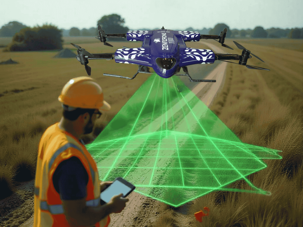
Alta Survey UAV systems have made this process much faster, easier, and more accurate. Drone Alta Survey methods let teams scan land from above and collect data in ways that save time and lower risk. With all these changes, Alta surveys done by drones are changing how things are done and setting a new standard for the business.
Why Alta Surveys with Drones Are More Efficient Than Traditional Methods
Alta Drones Make Land Surveys Faster and Accurate
Alta Drones can scan a property much quicker than people on foot. Alta land survey that used to take several days can now be finished in just a few hours. These flying tools take detailed photos and use GPS to track where each image comes from, making the final map precise.
As a result, mistakes happen less often. The data stays accurate and trustworthy for creating reports that meet legal and industry standards. With the help of smart software, Alta drones can even catch small changes in the land that people or older tools might miss. This level of accuracy comes in handy for legal reviews, project planning, and high-precision surveying work that must meet strict guidelines.
Land Survey Drones Cut Costs Without Cutting Quality
Land Survey Drones are not only fast but also a smart method of saving money. The overall cost of completing a survey is significantly cheaper because they don’t need a lot of people or heavy equipment.
This is especially useful for large or hard-to-reach sites. Drones can even collect all they need in just one flight, so you don’t have to constantly move between them.
To put it into perspective, here’s how drone alta survey methods compare to traditional ones:
Feature | Traditional Survey | Drone-based Alta Survey |
Time | Takes 3 to 7 days to complete | Accomplished in just 1 to 2 days |
Cost | Higher due to more manpower and equipment | Lower because fewer workers and tools are needed |
Safety | Surveyors must walk the entire site | Drones collect data safely from above |
Accuracy | More room for human mistakes | Highly accurate with GPS and automated tools |
In addition to all these benefits, Alta Survey Drone Solutions can handle different project sizes, whether a small piece of land or a large property. Many companies now see drones as a better and more trusted way to carry out Alta Survey Services because:
- Drones are fast
- Drones have lower operational costs
- Drones are safer to use.
Key Benefits of Drone-Powered Alta Surveys
1. Get Results Faster
A significant advantage of using drones for Land surveys is how quickly they complete the task. As soon as the drone lands, the data can be processed. This enables survey teams to respond to clients’ queries faster, allowing them to make decisions more quickly. Having quick access to Alta Survey Mapping information can make all the difference when buying land, getting permits, or planning a project.
Also, timely results help teams stay on the same page. Project managers, architects, and engineers can immediately use the data to adjust plans or budgets, allowing the project to stay on track.
2. Keep People Safe
Another significant benefit is safety. Some areas, like rough terrain, wetlands, or heavy traffic zones, are hard or dangerous to walk through. With drones, survey teams do not need to enter those spots. Everything can be done safely from above. By keeping people off the ground in risky areas, drones help reduce the chance of accidents and make the work site safer. This is especially helpful for industrial zones, steep land, or places near busy roads and traffic-heavy areas.
3. Reduce Mistakes with Smart Technology
Drones help avoid mistakes by using innovative technology and flying the same route each time. This allows them to gather data consistently and dependably, leading to more accurate results.
Drones carry powerful tools like:
- High-quality cameras
- GPS
- LiDAR
The software that comes with them also checks the data for problems to ensure clean and accurate end results. Because drones can fly the same path again in the future, it’s easy to keep track of changes over time. This is especially beneficial for projects that require regular Geospatial Data Collection and updates.
Applications of Alta Surveys in Different Industries

Construction Projects
The Alta Dorne Survey for Construction projects begins with understanding the land. Before anything is built, teams must determine exactly where roads, buildings, and utilities should be located. ALTA surveys offer this critical information, and drones accelerate the process by gathering more precise data in less time.
Drones do more than just save time. They give planners the exact details needed to design strong foundations and avoid costly mistakes later on. These surveys also help confirm that the work meets local zoning rules, which is especially important in busy city spaces. As projects expand in scale, effective communication becomes more crucial. Drone surveys benefit everyone involved, including contractors and municipal officials, by providing consistent and correct perspectives from which to work.
Real Estate
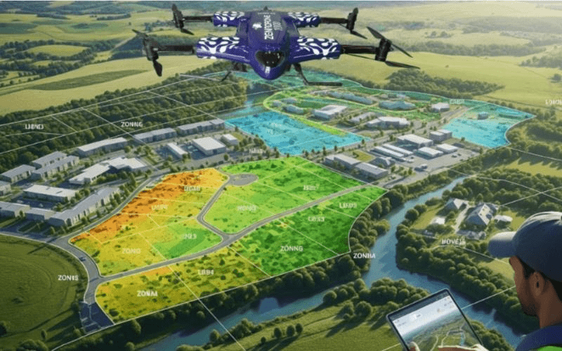
Alta Survey for Real Estate gives developers access to accurate land information. ALTA surveys show important features like property boundaries and access points. When paired with drone technology, they offer sharper images and faster reports, helping deals move forward more smoothly.
This is especially helpful for developers, real estate professionals, and legal teams, who need clear and updated data to make informed decisions. With drone surveys, buyers and sellers can better understand the land and feel more confident in the transaction. In the market nowadays, having the most recent Drone for Mapping and Surveying data gives you a strong edge. It helps speed up approvals, financing, and negotiations so deals can close more quickly.
Environmental Monitoring
ALTA surveys play an essential role in environmental work. They help landowners and environmental teams look closely at a specific area without disturbing it. Drones can fly over forests, hills, or wetlands to map the land and watch for changes over time, making them an excellent tool for protecting natural areas and tracking how the land is being used.
These surveys help monitor:
- Wildlife
- Water levels
- Erosion
- Fire damage
In addition, these surveys can help identify illegal land use or environmental hazards before they become serious problems, supporting better land surveying with drones and long-term environmental care.
How Alta Surveys Work: Step-by-Step Drone Process
Step 1: Preparing for the Survey
Everything starts with careful preparation. Before flying the drone, the survey team:
- Reviews the area using satellite images and property plans
- Determine the drone’s flight path to cover the entire site
- Inspect for obstacles like overhanging branches or power lines
- Place small markers on the ground that help guide the Alta survey mapping
- Handles permits and safety rule compliance
This early planning ensures the process runs smoothly and delivers accurate results.
Step 2: Data Collection with the Drone
This Alta Survey Data Collection process captures:
- High-resolution imagery
- Elevation profiles
- Land features
It also takes multiple shots that slightly overlap to ensure that the whole region is covered. At the same time, it saves GPS data, allowing researchers to determine the origin of each photo. Everything is automatically saved and can be used later.
For some projects, drones may also gather:
- Altitude data
- Infrared imagery or other sensor-specific readings
While the drone is in the air, the team constantly observes it in real time and adjusts as needed due to weather or any unexpected activity.
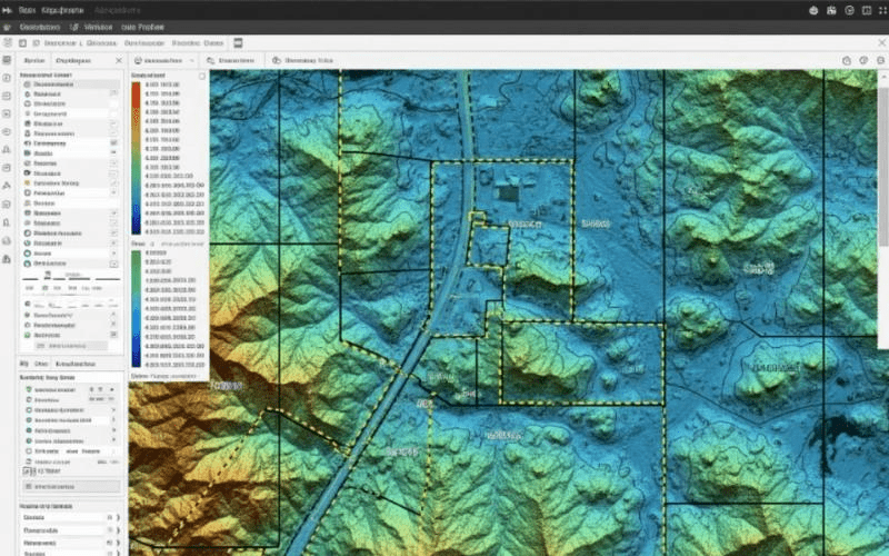
Step 3: Turning Data into a Report
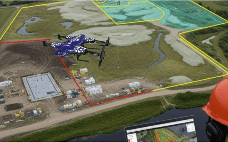
After the drone finishes its mission, the next step is to turn the photos and location data into something useful. The team uses special computer software to combine everything and create a clear map or 3D modeling with drones. The final report will show:
- Property lines
- Building locations
- Shared paths or driveways
Before delivering the report to the client, surveyors carefully check it to ensure it follows all the official rules. Once approved, the client can use it for legal document processing, planning, or other land projects that need accurate information.
File formats may include:
- CAD files
- GIS/map data
This makes it useful for many kinds of work, including construction, land sales, and aerial survey development.
Drone Technology Behind Alta Surveys
What Makes Drones So Smart Today
Drone Alta Survey technology, also known as Alta UAV systems, has improved substantially over the years. These intelligent flying vehicles can navigate predetermined paths, avoid obstacles, and accurately collect data. Some even include specialized sensors, such as LiDAR, that detect tiny variations in land height or surface features. These innovative features include:
- Photogrammetry
- RTK GPS
- Obstacle avoidance
To do all this, the drone employs flight software that changes its height and direction throughout the flight. This allows it to move smoothly and capture crisp images across the region. It also saves backup data inside, so the critical information is safe even if the connection is lost.
How Cameras and GPS Make Alta Surveys More Accurate
In Alta surveys, high-quality cameras and GPS tools play a significant role. The camera takes clear pictures from above, and the GPS marks the exact spot where each photo was taken. When used together, they help survey teams create detailed and trustworthy reports.
These tools also support a process called photogrammetry. This means using many slightly overlapping pictures to build a 3D model of the land. It allows people to study the area from different angles without visiting the site in person.
The GPS becomes even more exact when used with something called RTK, or real-time kinematic positioning. This helps the drone pinpoint locations with accuracy down to a few centimeters, which is very important for serious or complex projects needing UAV surveying services.
Why Choose a Professional Drone Surveying Service?
Certified Pilots Know What They’re Doing
Doing a drone survey requires more than just flying a drone. It needs someone who understands safety rules, flight paths, and data collection. A trained pilot knows how to fly in different weather, avoid mistakes, and keep everything safe during the job. That helps the whole project go smoothly and gives better results.
At ZenaDrone, every pilot is certified and trained to follow the law while flying. The team also knows how to handle special areas where flight is limited, ensuring everything is done correctly with drone surveying precision.
Professional Gear Gives You Better Data
The equipment used in a drone survey is just as necessary as the person flying it. ZenaDrone uses:
- Advanced RTK systems
- LiDAR
- AI-powered mapping software
This makes the results more complete and easier to work with. Top-quality gear can spot even the most minor changes in land shape. That detail is very helpful in legal work, land deals, and significant building projects where missing something could lead to costly problems.
Stay Legal and Fully Compliant
Alta surveys are subject to many different rules that operators must follow and comply with prior to execution. Banks and municipal governments may reject surveys that do not meet the ALTA and NSPS requirements. A trustworthy crew, such as ZenaDrone’s, understands all the steps necessary to ensure the study meets all standards. Following the rules entails more than simply avoiding mistakes. It improves your project, ensures its legality, and gives people confidence in the survey findings.
What Sets Zenadrone Apart in Drone Surveying Services?
Expertise in Alta Surveys
ZenaDrone has worked on various land surveys, including Alta surveys for Real Estate, construction, and large property projects. The team understands exactly what these surveys require and pays special attention to every detail. As a result, reports are clear, correct, and relied upon by experts in many fields. Keeping up with the most recent topographic surveying rules and best practices is part of the process. That way, each assignment is completed correctly and fulfills all requirements from beginning to end.
Cutting-Edge Tech That Gets the Job Done Right
ZenaDrone uses some of the most advanced tools in the field. With features like RTK GPS, LiDAR scanning, and high-quality cameras, each drone collects data accurately. Then, fast and smart software turns that data into full reports ready to use. These Alta Survey Drone Solutions help avoid mistakes, speed up the process, and give every project strong, detailed results from day one.
Our Clients See Results
ZenaDrone’s UAV Surveying Services have helped many clients succeed. For example, a developer needed an Alta survey on a 25-acre area with tricky ground. The team finished the job in less than two days, and the final report came early. That helped the client close the deal an entire week ahead of schedule. Other clients have used the service to meet tight deadlines, get permits faster, and receive quick approval from banks and lenders. These real results show how ZenaDrone makes a difference when it matters most.
Conclusion: Why Drone-Based Alta Surveys Are the Future
A good survey is the first step in building a strong foundation for any property project. An Alta survey ensures everything is clear and correct from the start, whether you are buying land, creating a new home, or selling land. Using drones takes that a step further. It makes the process faster, safer, and more precise. You can save time, cut costs, and avoid mistakes that could slow your project down.
Drone-powered Alta Survey Services is a smart approach for developers, investors, and environmental teams to get the whole picture. You get results you can trust without ever going to the site, and get them sooner than you may think.
ZenaDrone delivers reliable, fast, and compliant Alta Survey Services powered by cutting-edge drone technology. Whether buying land, developing a site, or preparing legal documents, our certified team ensures you get precise data without delays.
Book your free consultation today and discover how ZenaDrone helps you make smarter land decisions quickly and clearly.
Contact Us
Thank you for your message. It has been sent.